

|
Published: 20 December 2010
Groundbreaking models give fragmented landscapes new hope
Innovative scientific modelling by the Victorian Environmental Assessment Council (VEAC) has revolutionised our understanding of the state’s native vegetation and will help prioritise the way conservation dollars are spent in future.
|
|
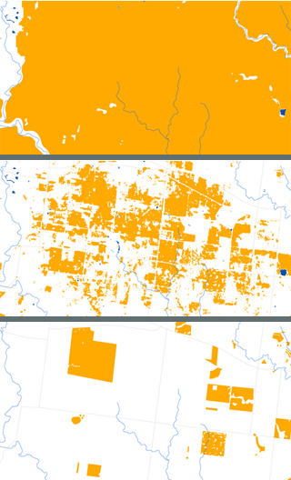
Maps of the distribution of plains grassland near Melbourne: (top) Pre settlement (centre) Mapped extent before 2005 and the new analysis (bottom) Estimated extent post VEAC analysis. The new modelling picks up the grasslands more effectively than previous analysis and enables all tenures to be mapped, not just the public estate. Credit: DSE
|
Previously, information on native vegetation was largely restricted to public land. The new models not only map where remnant vegetation occurs across the state – whether on public or private land – but the condition it is in, and how well it is connected to other bush remnants.
Victoria is the most highly cleared state in Australia. More than a thousand native species are threatened with extinction and whole communities of native grasslands and woodlands are at risk.1
The modelling, conducted by the Department of Sustainability and Environment (DSE), is part of a VEAC investigation2 that aims to identify opportunities for ecological linkages. The final report is due in March 2011.
Roadside reserves
The models have revealed that in many parts of Victoria, more than a third of remaining native vegetation is found along roadsides. This finding has profound implications for how those reserves should be managed, says VEAC Project Manager, Paul Peake.
Previously the main ecological role of roadside vegetation was seen as connecting larger patches of bush. But in areas where 50 per cent of the vegetation on public land is on roadside reserves, the roadsides themselves have become the patches. As a result says Peake, ‘the emphasis shifts towards building up the patches as core areas before attempting to connect them’.
|
|
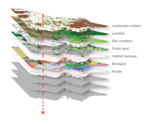
The layers of information contained within the new native vegetation model. Credit: DSE
|
Why not write off such small and scattered patches of bush along roadsides? ‘The problem with that’, says Peake ‘is that you would be writing off the biodiversity in a quarter of Victoria.’ While roadside patches may be small, they can still make a disproportionate contribution to the conservation of biodiversity within a region.
The models
The modelling and analysis builds on work published by DSE’s Arthur Rylah Institute, where Graeme Newell is an ecologist and modeller. His team’s work meshes together a range of remote sensing information including satellite imagery, data on soils, climate, terrain and a whole range of scientific information used to create the maps.
Unlike woody vegetation, native grasslands are difficult to detect from a satellite and hence map. For the first time researchers have been able to build a consistent view of the extent of native grassy vegetation. They have also modelled and mapped the condition or quality of vegetation — which has never been done before — at a large landscape scale. The condition maps integrate data from 17,000 on-ground assessments collected over five years.
Connectivity
‘It comes down to a question of resilience in the time of climate change’, says Newell. How can we best ‘accommodate connectivity for all those different plants and animals across the landscape, over large time scales?’
|
|
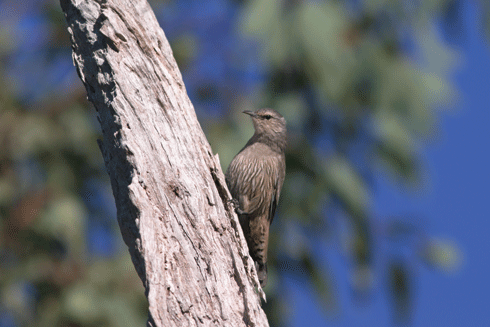
The brown treecreeper (Climacteris picumnus) is widely distributed across open woodlands and forests of eastern Australia but decline in abundance due to habitat clearance has been reported across most of its range. Rohan Clarke, Wildlife Images. |
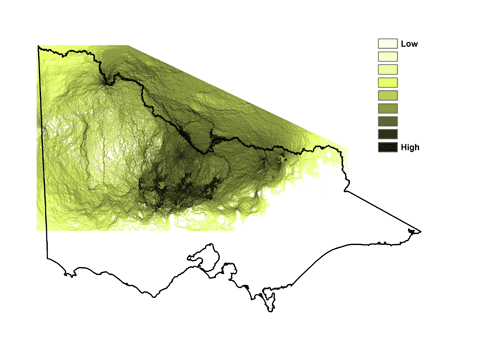
To assess the level of connectivity and how to enhance it, ‘Circuitscape’ software, was used to predictively map the way animals disperse. It uses the principles of electrical conductivity to find the path of least resistance between nodes of core animal habitat.
|
|
Circuitscape mapping for the brown treecreeper in Victoria. Circuitscape depicts probabilities of connectivity between select nodes of habitat patches. Credit: DSE
|
Visualising connectivity in this way helps to shift thinking about the multiplicity of ways plants and animals spread their genes across the landscape.
More information
1 Securing Our Natural Future: A white paper for land and biodiversity at a time of climate change, http://www.dse.vic.gov.au/dse/nrence.nsf/childdocs/-A87712F40FADECFFCA25767300162346?open
2 http://www.veac.vic.gov.au/investigation/remnant-native-vegetation-investigation

