

|
Published: 4 July 2011
Melbourne event an epicentre of seismic activity
The world’s leading volcanologists, seismologists and thousands of other scientists are converging on Melbourne to discuss the state of planet Earth – including more effective ways to predict and prepare for natural catastrophes such as earthquakes, tsunamis and volcanic eruptions.
|
|
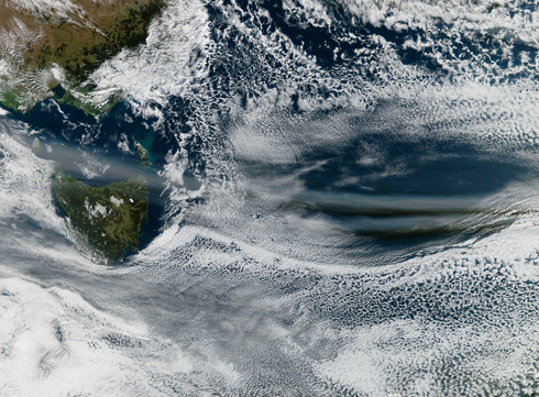
A thin filmy ribbon of volcanic ash streams above Tasmania. The Chilean volcanic eruption on 4 June pumped ash more than 14 km into the atmosphere, where it entered the jetstream and blew east to Australia, grounding aircraft. Credit: NASA/Jeff Schmaltz/MODIS Rapid Response Team
|
‘Earth on the Edge: Science for a Sustainable Planet’ is the theme of the general assembly of the International Union of Geodesy and Geophysics (IUGG), being held in Melbourne from 28 June to 7 July – only the second IUGG assembly ever held in Australia. The assemblies, which are held once every four years, bring together researchers working in earth, atmospheric, oceanic and polar sciences.
IUGG President, CSIRO’s Dr Tom Beer – the first Australian to hold the position – says the assembly fosters research collaboration and dialogue between scientists from 69 countries. This massive shared knowledge base will improve our understanding of climate change, global mean sea level rise, volcanoes and earthquakes. It will also provide more effective information to those responsible for sustainably managing planetary resources such as fresh water.
‘Geophysics in its broadest sense means both solid-earth and fluid geophysics,’ explains Dr Beer. ‘This covers volcanology, seismology, meteorology, oceanography, freshwater hydrology, aeronomy (study of the upper atmosphere) and the cryospheric sciences (focused on glacial and polar ice sheets).’
‘Geodesy is the study of the shape of the Earth, which is important, for example, for setting standards for GPS satellites. Determining exactly what the geoid is (ie the hypothetical shape of the Earth, coinciding with mean sea level and its imagined extension under or over land areas) provides a reference platform for measuring the altitude of satellites.’
Keynote speakers at the assembly include one of the world’s most respected experts on sea?level rise, Dr Annie Cazenave from France. Her group’s recent research, based on satellite data, shows that while sea level was rising at a mean rate of about 1.7 millimetres per year during the 20th century, the rate has increased to more than 3 millimetres per year since the early 1990s. CSIRO’s Dr John Church is chairing a separate panel on sea-level rise at the assembly.
The availability of more accurate data from Argo profiling floats and other high?tech instruments has also led Dr Cazenave’s team to conclude that while ocean thermal expansion has recently slowed down, ice mass loss from ice sheets has significantly accelerated.
Dr David Vaughan from the British Antarctic Survey will discuss difficulties involved in estimating the contribution of polar ice sheet melting to sea level rise. Glaciologists are hamstrung by a lack of basic data; according to Dr Vaughan, parts of Mars are better mapped than the surface of Earth beneath the ice sheets.
Another keynote speaker – Dr Steve Self, a volcanologist with the United States Nuclear Regulatory Commission – will discuss the impacts of volcanoes. Dr Beer points out that being better able to predict the behaviour of volcanic ash plumes will have economic and social benefits.
‘Before the 2010 Icelandic eruption that stopped air traffic over Europe, it was known from two previous incidents that invisible clouds of volcanic ash could stop aircraft engines,’ he says. ‘That led to a blanket exclusion and wholesale closure of airports in Europe whenever there was any volcanic ash around.
‘If authorities had better information about the ash plumes, they could decide whether in certain situations aircraft could safely fly through the ash. Scientists have been getting together with numerical modellers and are now getting new results as to how and when to issue better volcanic advisories to aircraft.’
Such information is particularly vital for more densely populated developing countries when preparing for natural catastrophes. For example, since the Bhola cyclone that killed almost 500?000 in Bangladesh in 1970, the country has built shelters near the coast – along with picture-based public alert systems – in preparation for tsunamis or cyclones.
The way scientific data is collected and managed also affects the way that decision makers transform information into ‘intelligence’. The Bureau of Meteorology’s Dr Greg Ayers will discuss the new National Plan for Environmental Information at the assembly. The plan has been initiated by the Australian Government to improve the quality and coverage of environmental information through more coordinated data collection, management and use.
More information
IUGG 2011 Assembly, www.iugg2011.com
CSIRO sea-level rise site, http://www.cmar.csiro.au/sealevel/

