|
Published: 21 November 2011
Draft plan for eastern marine reserves open to comment
The Australian Government has just released a draft marine bioregional plan and proposed marine reserves network for Australia's Temperate East Marine Region. The draft plan is now open to public comment for a three-month community consultation period.

|
|
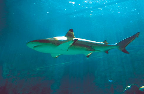
The Temperate East Marine Region is home to the east coast population of the critically endangered grey nurse shark and includes many reef-building coral species. Credit:
Willem van Aken/scienceimage
|
The Temperate East Marine Region covers approximately 1.47 million square kilometres of temperate and subtropical ocean.
It is made up of Commonwealth marine waters starting from the southern boundary of the Great Barrier Reef Marine Park in the north, to Bermagui in southern New South Wales. The region also includes the waters surrounding Lord Howe and Norfolk Islands.
Commonwealth waters start 5.5 kilometres off the coast. The marine reserves network will not include state waters.
‘The Temperate East Marine Region has many unique features and is home to a large number of protected species and species that occur nowhere else in the world,’ said Mr Burke.
‘It is home to the east coast population of the critically endangered grey nurse shark and includes the southernmost extent of many reef-building coral species.
‘Several significant seamount ridges run parallel to the coast in this region, including the extensive Tasmantid Seamount Chain. The Taupo Seamount rises roughly 4700 metres from the ocean floor – twice as tall as Mount Kosciuszko.
‘Scientists have recently discovered that these features support hundreds of species, including some previously unknown to science.
‘Through our initial consultation in the development of these draft plans, where possible, we have avoided having an impact on local jobs or people who love to fish.’
‘Now there will be a further opportunity for communities to have their say in this important process and I encourage people to get involved.
‘We extended the 60-day consultation period to 90 days to ensure people have every opportunity to provide feedback.’
There are nine proposed marine reserves in the Temperate East Marine Region and these are broken down into six types of zones to secure conservation benefits and where possible minimise impact on industries and people who like to fish.
The marine reserves network also incorporates the existing Commonwealth marine reserves in the region.
During the three-month public consultation period, officers from the Department of Sustainability, Environment, Water, Population and Communities will be visiting coastal centres in the Temperate East Marine Region. They will hold information sessions and meet with representatives of various industries and stakeholder groups.
Public information sessions will be held in Bermagui, Ulladulla, Jervis Bay, Port Stephens, Forster, Coffs Harbour, Lord Howe Island and Norfolk Island. The consultation period will close on 21 February 2012.
The Government also announced that its proposals for the Coral Sea will be released soon.
Source: Ministerial media release


