

|
Published: 20 March 2012
Satellites keep track of ghost nets
To better understand the movement and impact of ghost nets (lost or abandoned fishing nets) GhostNets Australia (GNA) has embarked on a program to track these destructive nets off the Northern Territory coast.
|
|
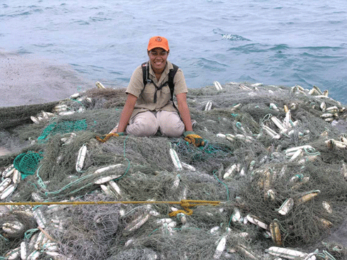
Large Taiwanese net retrieved from ocean off North East Arnhem Land, Northern Territory.
Credit:
photo by Jane Dermer, courtesy Dhimurru Aboriginal Corporation
|
‘We are still searching for the answers to some pretty important questions, such as, why do some regions receive more nets than others? How long does a ghost net stay in the water before it is beached? How does a ghost net move? How many animals are entrapped by a ghost net?’ says Jen Goldberg, GNA project officer.
GNA will track the nets by satellite using prototype ‘Microstar’ drift net trackers developed by US company Pacific Gyre. These devices will be attached to ghost nets and will track currents and collect remote and environmental data related to the movement of the nets.
The Microstar trackers are designed to survive several months at sea and have a battery life of up to two years. GNA hopes to provide regular updated maps of the progress of nets, and any findings, and make these available on the GNA website.
In launching the trackers, GNA sought assistance from commercial fishing operators Bruce and Juanita Davey of the fishing vessel FV Wildcard. Mr and Mrs Davey have been active campaigners against ghost nets and their impacts, and have frequently removed large ghost nets from north Australian waters.
Recently the FV Wildcard encountered a net on a large reef system one mile east of Marchinbar Island, the most north–easterly point of the Northern Territory. As it was too large and heavy to bring aboard, they tagged the net with a Microstar tracker that enabled GNA to track it in real time while at the same time informing authorities of the shipping hazard.
Through the tracking device it will be possible for GNA to accurately locate this net if it ever reaches the Australian mainland, with ranger groups around the Gulf of Carpentaria then able to examine the net for entangled wildlife before permanently disposing of the net.
In further developments, GNA has recently worked closely with oceanographer Dr David Griffin from CSIRO to determine the likely location of a large net reported at sea 24 km from Weipa.
Ben Bright, a recreational fisherman, found the net when he went to rescue some birds entangled in it. Using a hand held GPS he marked the location, filmed some of the net, and reported it to GNA. The film showed a very large net the size of a football field, with a drop in places of 90 feet, and many entangled fish and other marine animals. Dr Griffin used the satellite-tracked net to inform his existing model of sea currents and tides to more accurately predict the likely location of this drifting net.
‘Unfortunately nets such as this “GR24 net” are designed to be invisible and are therefore incredibly difficult to see, even when you are on top of them,’ says Ms Goldberg.
‘The coastguard plane was unable to relocate the net. Even so this is an example of technology and applied science working together on a real time issue and the future applications are very exciting.’
The information gained from drift net tracker deployment will complement the work of other GNA project partners such as CSIRO’s marine debris research.
Source: Ghost Nets Australia

