

|
Published: 25 June 2012
Quiet on board please: science underway
The first massive pieces of the hull of Australia’s new scientific research ship, RV Investigator, were winched into place last month in a Singapore shipyard. CSIRO’s Dr Brian Griffiths and ECOS writer Michele Sabto give readers a preview of the impressive technology mounted in and on the hull.
|
|
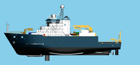
Starboard view of Australia’s new Marine National Facility vessel RV Investigator Credit:
CSIRO
|
Australia has responsibility for an area of ocean larger than our land mass, and a coastline stretching 70,000 kilometres. Our territory encompasses the world’s greatest diversity of marine species and habitats within a single nation. How do our scientists move around this watery world?
Southern Surveyor is Australia’s grand old lady of scientific sea expeditions. Operated by the CSIRO through the Marine National Facility, she has been a research vessel for 22 years and has served Australia’s scientific community well, having carried out 111 Marine National Facility voyages and chalked up an astonishing 481,550 kilometers of travel. That’s equivalent to going around the equator 12 times – further than the distance from Earth to the Moon!
Crews on Southern Surveyor have discovered submarine volcanoes between Fiji and Samoa and have examined climate records from ancient corals, producing a carbon chemistry map of the Great Barrier Reef region. On the now famous ‘Vortex Voyage’, a 2006 expedition led by Professor Anya Waite, Southern Surveyor came across a massive 200-kilometre wide vortex off the coast of Rottnest Island, Western Australia. This one voyage alone prompted more than 20 international journal papers.
But, Southern Surveyor’s days as Australia’s premier research vessel are numbered. It will soon be time for a new ship to step up. That ship is RV Investigator.
Due for completion in 2013, RV Investigator will be 93.9 metres long (Southern Surveyor is 66 metres). Each voyage will be able to accommodate 40 scientists (Southern Surveyor is limited to 15), and the ship will be able to go to sea for up to 60 days, covering 10, 000 nautical miles per voyage.
A high-tech hull
The hull of RV Investigator and its machinery have been designed to ensure that the vessel is as quiet as possible. This is because radiated noise interferes with the operation of hull-mounted instruments and alters the behaviour of fish and aquatic mammals. Noises made by the ship will be monitored by four multifrequency hydrophones on the hull. As the ship ages, it is expected that new noises will emerge.
When a hull moves through water, it also produces another type of interference: micro-bubbles. As an analogy, think of driving along a road at night and getting caught in a snowstorm. All of a sudden, you can’t see. Because the underwater micro-bubbles either absorb the signal from the ship’s instruments or reflect it, it is hard to get a good signal, and the range of the instruments decreases.
RV Investigator gets around the interference of the bubble layer in two main ways: a gondola and drop keels.
The gondola
To get instruments down below the bubble layer, they will be carried on a large gondola, like a winged keel, mounted 1.5 metres below the hull. A lot of time has been spent running scale models of the hull in tanks, looking at where the bubbles might be generated. The gondola should operate at peak efficiency, because it will be well below the bubble zone.
At around 13 metres long and 9 metres wide, the gondola is able to carry several important acoustic instruments. These include two ‘swath mappers’ to map the seafloor. Swath mappers contain an array of transmitters that send out acoustic signal beam downwards and sideways, and then measure the signal strength and return time. This builds up a topographic map of the sea floor under the ship. One of the swath mappers operates down to about 500 metres and is used on the shelf and the upper slope for obtaining very high-resolution topographic maps of the sea floor. The other, a full ocean-depth mapper, will operate down to a depth of about 7 kilometres and at distances up to about 15 kilometres on each side of the ship – providing a swathe of the sea bottom 30 kilometres wide.
Sea floor maps are critical for understanding many of the geological processes occurring on the sea floor. For example, they can help with determining where undersea landslides – which can cause tsunamis – may occur.
The gondola also contains an instrument that can indicate the makeup of sediments in the sea floor. Sedimentation processes are critical for a whole series of geoscience capabilities. The ‘sub-bottom profiler’ emits a signal that penetrates up to about 25 metres in sand and about 100 metres in loose sediments. The return signal allows the layers of mud, sand and rock that make up the ocean floor to be displayed.
|
|
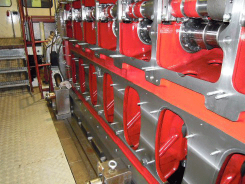
One of the RV Investigator’s three main engines Credit:
CSIRO
|
Drop keels
Another unique feature of this vessel is a couple of drop keels that contain an array of scientific instruments. The keels are about 1.3 metres wide by about 3.6 metres long – the scale of an aircraft wing – and are kept inside a tube in the ship. They can be lowered down to about 4 metres below the hull, putting the acoustic equipment inside them well below the bubble zone as the vessel goes through the water.
Seawater inlets on the keel undersides allow scientists to collect uncontaminated seawater samples.
Other instruments mounted in, or on, the keels can:
• measure the speed, direction and depth of currents – understanding current speed and direction is key to understanding the transport of heat in oceans
• indicate fish abundance and size
• detect fish schools and individual fish, giving location and depth relative to the vessel as it moves through the water
• measure the velocity of sound in water – sound velocity affects depth calculations
• measure the width and height of scientific trawl net carried behind RV Investigator – the net can be up to 4 kilometres deep and 6 kilometres long. Knowing how the size of the net mouth opening changes it moves through the water helps calculate abundance estimates for trawl catches, and improves understanding of the general behaviour of trawl nets
• provide data on the position of instruments towed by or moored to the ship, increasing the spatial accuracy and precision of measurements.
Follow the progress of this very clever ship on RV Investigator’s blog
More information
CSIRO Marine and Atmospheric Research

