Print this page

Published: 23 July 2012

Tibetan glaciers shrinking rapidly


Most of the glaciers on the Tibetan plateau and surrounding region are retreating rapidly, according to a study based on 30 years of satellite and field measurements.

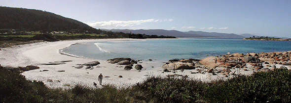
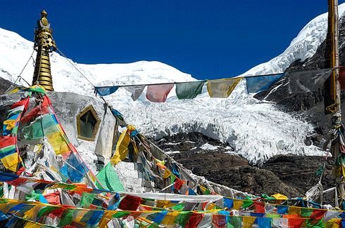
On the Tibetan plateau, it snows at the same time as the summertime Indian monsoon; a slight increase in summer temperatures can affect glaciers drastically.
Credit: Andy Hares/flickr

The research by Yao Tandong, a glaciologist at the Chinese Academy of Sciences' Institute of Tibetan Research in Beijing, and his colleagues has been published in the journal, Nature Climate Change.

It ‘is the most comprehensive survey to date in the region’, says Tobias Bolch, a glaciologist in the University of Zurich, Switzerland.

The Tibetan plateau and the bordering mountain ranges, including the Himalayas, the Karakoram, the Pamir and the Qilian make up a vast region known as the Third Pole, home to 100,000 square kilometres of glaciers that supply water to about 1.4 billion people in Asia.

The status of the glaciers has been a point of contention. Earlier this year, an analysis of 7 years' worth of measurements taken by the Gravity Recovery and Climate Experiment (GRACE) satellite mission suggested that high-altitude Asian glaciers on the whole are losing ice only one-tenth as fast as previously estimated, and that glaciers on the Tibetan plateau are actually growing.

Yao and his colleagues analysed satellite measurements of the lengths and surface areas of about 7100 glaciers. They also studied changes in the mass balance — the difference between accumulation and loss of ice — of 15 glaciers that they have painstakingly measured for decades.

‘The majority of the glaciers have been shrinking rapidly across the studied area in the past 30 years,’ says Yao. And the rate of retreat has been accelerating.

But embedded in this general trend, says Yao, is a large variation in different parts of the Third Pole. For instance, glaciers in the Himalayas are retreating faster on average than those in the Karakoram and the Pamir.

To unravel the mechanisms underlying this variation, the researchers turned to climate records of the entire region. They found that changes in the glaciers, especially in their mass balance, depend in large part on whether the ice is under the influence of the Indian monsoon, or the westerlies, the prevailing winds from Europe.

‘Temperature rise is important,’ says Yao. ‘But its effects on glaciers also depend on climate regimes.’

In places dominated by the westerlies, such as the Karakoram and the Pamir plateau, glaciers gain their mass mostly from winter snow, and so are less affected by warming because temperatures in winter are still below zero. In the eastern and central Himalayas, however, it snows mainly during monsoon season, and a slight increase in summer temperatures can affect glaciers drastically.

In the past few decades, the Indian monsoon has been getting weaker. By contrast, the westerlies are getting stronger. ‘This explains why most glaciers that are either stable or advancing are in the Karakoram or the Pamir plateau,’ says Yao.

The study raises serious issues with assessments based on GRACE measurements. Some climate scientists say that the measurements were taken over too short a time to capture the impact of climate change. Others question whether the satellite is suited to studying ice changes in the Third Pole.

The Tibetan plateau contains closed catchments where glacier melts can be stored in lakes, the soil and underground. A survey by Yao and his colleagues found that the area of glacial lakes on the plateau has increased by about 26 per cent since the 1970s.

‘As the GRACE satellites can only feel the gravitational pull and can’t tell the difference between ice and liquid water, they may have mistaken expanding glacial lakes for increases in glacier mass,’ says Yao.

John Wahr, a remote-sensing expert at the University of Colorado Boulder and lead author of the GRACE study, concedes that the criticism is valid. ‘This is an important weakness of GRACE for any non-polar glacier study,’ he says.

‘The study highlights the complexity of glacier responses in the region and the importance of ground truth for making accurate assessments,’ says Lonnie Thompson, a glaciologist at Ohio State University in Columbus, and a co-author of the latest paper. ‘Mass-balance studies are extremely labour intensive and can often be dangerous, but there is never a substitute for boots on the ground.’

Source: Jane Qiu/Nature Climate Change


Published: 25 November 2014

Things warm up as the East Australian Current heads south

Jaci Brown

Occasional erratic bursts southward of the East Australian Current (EAC) are thought to have moderated the weather of south-east Australia this autumn and winter and they continue to introduce tropical and sub-tropical marine species to Tasmanian waters.

Tasmania’s east coast: tropical and sub-tropical marine species normally found off NSW are finding their way further south, thanks to changes in the East Australian Current.

Ocean monitoring by Australia’s Integrated Marine Observing System is providing scientists with significant new insights into the changing structure of the EAC. Over the past 50 years sporadic warm bursts have become more common as the EAC moves further south. With global warming, the warm burst we’ve seen this year may also become the norm.

Had our little friend Nemo the clownfish been riding the EAC this year he might have found himself holidaying in Tasmania rather than admiring the Sydney Opera House. He wouldn’t have been on the trip alone, though. Sea nettles (Chrysaora spp.) have headed from their usual home in Sydney to be found for the first time ever in Tasmania and the Gippsland Lakes.

<i>Chrysaora woodbridge</i>, or sea nettle, was found in surprising numbers in Tasmania this year.
Chrysaora woodbridge, or sea nettle, was found in surprising numbers in Tasmania this year.
Credit: copyright Lisa-ann Gershwin

Waters in the EAC travel southward along the east coast of Australia, with most of it splitting from the coast near Sydney and heading for New Zealand. A small part of the current, known as the EAC Extension, works its way southward past Victoria and Tasmania.

A typical signature in this region are the large eddies, around 200 kilometres across and hundreds of metres deep. Some of the warm water is trapped here along with marine life.

The EAC starts at the Great Barrier Reef and travels south to Sydney before turning eastward to New Zealand. Some of the water can still push southward via a series of strong eddies.
Credit: Eric Oliver

This year a larger proportion of the EAC was sent southward instead of breaking away to the east. Winter ocean temperatures off Bass Strait were around 19°C, an increase of 4°C. This impacted local fishing, beach conditions and the weather.

In the video (above) the animation on the left shows the actual sea surface temperature and speed of the ocean currents. The animation on the right shows the difference in the temperature from average conditions.

Through autumn and winter, you can see two interesting changes occur. A strong warm current heads down the coast from Sydney to the coast of Victoria. At the same time, warm water peels off from the EAC and swirls around in large eddies as it meanders toward Tasmania.

An unusual catch down south

One advantage of warm eddies is the refuge they provide for tuna. They congregate in the centre of the eddy where the waters are warm and dine at the nutrient-rich edges.

Local fishers in north-east Tasmania report a remarkable year that allowed them to fish longer than usual, providing game fishers with more opportunities to catch tuna.

Last summer’s (2013–2014) warmth provided an abundance of skipjack and striped marlin, while winter brought a run of bluefin tuna.

Redmap is a website where locals can report sightings of marine species that are unusual for a given area.

Last summer a manta ray, a tropical cartilaginous fish (in a group including rays and skates), was sighted off the north-eastern coast of Tasmania. Previously the southern-most sighting of a manta ray was just south of Sydney.

<i>Manta birostris</i> spotted off north-east Tasmania on Australia Day 2014.
Manta birostris spotted off north-east Tasmania on Australia Day 2014.
Credit: Redmap/Leo Miller

It’s not just new species visiting Tassie either. Local jellyfish such as the Lion’s Mane (Cyanea) – more commonly known as ‘snotty’ – are usually quite elusive, but turned up in unprecedented numbers last summer in Tasmania.

But there’s a catch

This movement south of the EAC may have an impact on other systems, including our health. We rely on fish such as those from the Tasman Sea as a source of omega-3 fatty acids for our brain health. But the concentration of omega-3 fatty acids in the fish is likely to decrease with global warming.

Algae are the original source of fatty acids. As our waters warm, we will see more of the algae from the tropics take up residence in the south-east.

But the algae from the tropics are much smaller, which means more steps in the food chain from the algae to the fish we eat. The more steps in the food chain, the more the omega-3 fatty acids in the fish are replaced by fatty acids that are less favourable to brain health.

The warmer coastal waters also contributed to the balmy autumn and winter in south-eastern Australia this year. Afternoon sea breezes cool coastal temperatures by drawing cool oceanic air onto the coast.

Sydney’s heat wave in May this year had 19 consecutive days of 22°C or more – this is partly due to the sea breezes failing to bring in the usual cooling air.

What’s causing the EAC to move south?

Over the past 50 years the EAC Extension has stretched about 350 km further south. This extension doesn’t happen smoothly but in erratic bursts.

The southward extent of the EAC is controlled by the collective behaviour of the winds between Australia and South America. Over that same 50-year period these winds changed their pattern due to a strengthening of a climate system known as the Southern Annular Mode.

The changes to this mode have been attributed to a combination of ozone depletion and increasing atmospheric CO2.

One of the most robust and consistent responses of the climate system to increasing CO2 is a further strengthening of the Southern Annular Mode.

So the result will likely be a further enhancement of the EAC extension southward and even warmer waters in the Tasman Sea.

Dr Jaci Brown is a senior research scientist with the Centre for Australian Weather and Climate Research (CAWCR), a partnership between CSIRO and the Bureau of Meteorology. Her research focuses on the El Nino Southern Oscillation (ENSO) and climate change. This article was originally published on The Conversation. Read the original article.


ECOS Archive

Welcome to the ECOS Archive site which brings together 40 years of sustainability articles from 1974-2014.

For more recent ECOS articles visit the blog. You can also sign up to the email alert or RSS feed