

|
Published: 13 August 2012
Mapping the outback’s hidden ancient river valleys
Researchers have mapped the network of ancient river catchments – some larger than the Murray-Darling Basin – that store the massive volumes of regional groundwater beneath arid Australia.
|
|
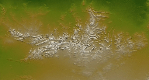
Davenport Ranges, Northern Territory, taken from the US space shuttle, Endeavour: This 270 x 145 km birds-eye-view hints at the underlying ‘paleovalleys’ hidden beneath these already-ancient surface features. Credit:
NASA/JPL/NGA
|
According to the report, ‘Water for Australia’s arid zone – identifying and assessing Australia’s palaeovalley groundwater resources’, the estimated annual volume of groundwater currently extracted from the ancient buried river valleys is more than 200 gigalitres in Western Australia, 14 gigalitres in South Australia and 8 gigalitres in the Northern Territory.
‘Paleovalley groundwater resources are essential to sustaining mining operations, horticulture, tourist sites, and many thousands of bores on pastoral stations’, said Geoscience Australia’s Dr Steven Lewis, project leader for the paleovalley program.
‘Prior to this project there was no coordinated investigation at a national-scale to improve our knowledge of paleovalley aquifers. Nor was there a well defined approach for mapping and characterising paleovalley aquifers as prospective water resource targets.
‘An accurate account of the water recharge processes is critical to inform decisions on how extraction should be handled to ensure sustainability of the resource.’
A key project output was the development of a map showing approximately 200 discrete palaeovalleys in Western Australia, South Australia and the Northern Territory.
‘Some of these paleovalleys were larger than the Murray-Darling River system, and we have mapped several that began in the Northern Territory and ran westwards until they eventually flowed into the Indian Ocean,’ Dr Lewis said.
‘In undertaking this work, we also recognised the importance of paleovalleys to the mineral exploration industry, which could utilise naturally occurring groundwater that has up to four times the salinity of sea water.’
But while there is scope for extracting substantial volumes of groundwater resources across arid Australia, the National Water Commission points to the need for future development decisions to take into account the principles agreed under the National Water Initiative for the sustainable and economically efficient use of water resources.
The $4.935 million study, commissioned by the National Water Commission, was undertaken by Geoscience Australia in association with state/territory governments, mining and community organisations, scientists and consultants.
Lead authors Dr Lewis and Dr Pauline English, also from Geoscience Australia, presented the findings of the paleovalley groundwater research project at the 34th International Geological Congress in Brisbane last week. A related map will soon be available from the Geoscience Australia website.
Source: Geoscience Australia

