

|
Published: 29 April 2013
Wiki seeks local ‘ground truth’ to help build better maps
A new project based on a collaboration between Australia’s AusCover facility and Europe’s Geo-Wiki Project will enable anyone to contribute local knowledge to the development of more accurate land cover maps.
|
|
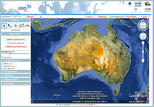
The geo-wiki interface, showing the Google Earth backdrop. Credit:
TERN
|
AusCover, a project of the Terrestrial Ecosystem Research Network (TERN), is developing an Australian geo-wiki system that will allow people to review land-cover maps created by AusCover and its partners.
With Google Earth as a backdrop, users of the geo-wiki can use their knowledge of their local area to determine if the land-cover classification shown in the map is correct. They can submit information about the area to support the validation and improvement of the map. The submitted information is recorded and used iteratively to produce more accurate maps. A smartphone app will make it easier for users to upload field photos and GPS locations to the geo-wiki.
Given Australia’s size and the remoteness of many areas, obtaining accurate validation data for maps has been a challenge in the past. By harnessing the collective knowledge of citizen-scientists anywhere in the country, the geo-wiki system offers a way to improve capacity for map validation.
But the geo-wiki system is not just designed to harness information from users – it also provides an avenue for users to access the data within the system. Features include:
-
user access to all submitted validation data;
-
the ability to run basic statistical analyses on submitted data;
-
a mobile app to upload field photos and GPS locations;
-
the ability to support land-cover maps with different spatial resolutions;
-
better land-cover map metadata information.
Ultimately, the Australian geo-wiki will allow any person to use their local knowledge to improve the validation of maps produced by state and federal agencies, non-government organisations, researchers and others. By building researchers’ capability to validate and update maps, the geo-wiki will enable better assessment, management, and monitoring of environments across the continent.
The Australian geo-wiki system is due to be released in late May. It will be on show at the IEEE International Geoscience and Remote Sensing Symposium in Melbourne from 21–26 July 2013.
AusCover provides a national expert network and data delivery service for provision of biophysical remote sensing data time-series, continental-scale map products, and selected high-resolution datasets over TERN sites in Australia. Coordinated by the CSIRO, AusCover supports a nationally consistent approach to the delivery and calibration of satellite-derived datasets.
Source: TERN

