

|
Published: 7 October 2013
Windy weather: a sign of dusty days ahead?
In recent weeks, strong winds swept through South Australia, New South Wales and Victoria. Apart from the financial cost of dust storms caused by such strong winds – the one that swept through Sydney in September 2009 caused $300 million damage – the dust can be bad for the nation’s health, ecosystems, agriculture, transport and infrastructure.
|
|
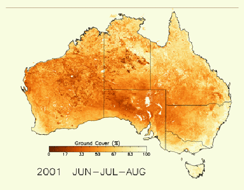
Changes to groundcover over time can be mapped – here, darker areas mean ground is exposed and more at risk of erosion (the animated version is here). Credit:
Australian Government, Department of the Environment
|
One way to understand the risks of dust storms is to marry weather forecasts with the potential dust sources across the country and see if they are going to meet up.
CSIRO scientist, Dr Juan Pablo Guerschman, has been working with Australian, state and territory governments to strengthen Australia’s dust and ground cover monitoring expertise.
‘Using satellite products we can estimate landscape properties of interest across the Australian continent like the proportion of the land that is covered by vegetation – either green or dry – or is bare soil,’ he says.
‘When there’s windy weather, it means that there’s a risk of dust storms and erosion of our soil and so particularly in spring we know that our data products will be in demand.’
Every eight days a new image comes through from a US satellite called MODIS. Dr Guerschman and his team have developed a system that takes that satellite information, runs it through mathematical calculations and delivers information about groundcover through portals like AusCover and served via the National Computer Infrastructure.
This is then picked up by data users such as the Community DustWatch program to assess where there might be sources of dust. The DustWatch program tracks wind erosion across Australia and produces a range of maps and products for use by governments and land managers and to warn agencies monitoring air quality of incoming dust storms.
Dr John Leys, Community DustWatch Coordinator, says that by combining weather station information, indicating the wind direction, with CSIRO groundcover information they can look for possible sources indicated by bare ground.
Dr Leys and his team then connect with their network, sometimes by phone or by email, to find out what is happening in that area.
‘This data from CSIRO has provided significant benefit to us,’ he says. ‘We can now get very quick spatial understanding of the landscape to see where bare ground might be a source of dust. When dust is measured in the DustWatch network of instruments, we can quickly find out where the dust is coming from.’
‘The dust storm that occurred (on 24 September) originated from two source areas, Lake Eyre and another area with low groundcover that has been caused by an increase in feral animals.’
‘This information from CSIRO is the most rapidly available data in Australia and it is critical.’
According to Dr Leys the cover in the rangelands of Australia has reduced over the last three months. Many areas have lost a substantial amount (about 30 per cent) of groundcover. This has been due to lack of rain, extremely dry temperatures and higher feral animal numbers.
Beyond dust-watching this type of research is also useful in Australia, for example, managing grazing and other land management practices and tracking our carbon budgets.
Across the world, researchers can link this land cover information with biomass and animal production models to understand how we can sustainably produce more food.
Source: CSIRO

