

|
Published: 13 January 2014
Increased estimate of sea-level rise contribution from West Antarctica
The rate of ice loss from the West Antarctic appears to have accelerated sharply in the last four years, European scientists say.
|
|
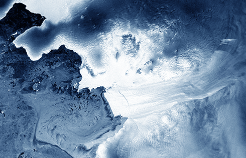
The Pine Island Glacier in West Antarctica, from the ESA’s Envisat satellite. Pine Island is the largest glacier in the West Antarctic Ice Sheet and one of the fastest ice streams on the continent, flowing into Pine Island Bay in the Amundsen Sea. Ten per cent of the West Antarctic Ice Sheet drains out to the sea by way of this glacier. Credit:
ESA
|
Data from the European Space Agency’s Cryosat – a satellite with a radar altimeter that can peer through the clouds and ‘see’ in the dark – have confirmed that 150 cubic kilometres of ice are drifting into the Southern Ocean each year. This rate is much faster than that calculated in 2010.
From observations gathered between 2005 and 2010 by 10 different satellite missions, Antarctic scientists and oceanographers calculated that the melting of ice from the West Antarctic peninsula was causing global sea levels to rise by 0.28 mm a year. The latest survey suggests the sea-level rise contribution from this area is 15 per cent higher than that earlier estimate.
The figures were revealed at the autumn meeting of the American Geophysical Union in San Francisco. Most of the ice loss comes from glaciers flowing into the Amundsen Sea.
‘We find that ice thinning continues to be most pronounced along fast-flowing ice streams of this sector and their tributaries, with thinning rates of between four to eight metres per year near the grounding lines – where the ice streams lift up off the land and begin to float out over the ocean – of the Pine Island, Thwaites and Smith glaciers,’ said Malcolm McMillan of the University of Leeds in the UK.
The increase could be due to faster thinning, or it could be down to more accurate measurement, because Cryosat has more advanced instruments and circles the planet in a near-polar orbit, to cross territory no other observers could hope to see.
Cryosat will be followed by another series of European satellites, to be launched from 2014 onwards. Each of these Sentinels – that is their name – will have synthetic aperture radar instruments that will monitor a 250 kilometre-wide strip of the globe with each orbit.
They will work in pairs and not just keep an eye on polar ice but will also cover Europe and Canada every one to three days, as well as monitoring major shipping routes.
Source: Climate News Network

