

|
Published: 2 December 2014
Underwater robot sheds new light on Antarctic sea ice
Scientists from the UK, USA and Australia have developed the first high-resolution 3D maps of Antarctic sea ice using an underwater robot. The technology provides accurate ice-thickness measurements from areas that were previously too difficult to access.
|
|
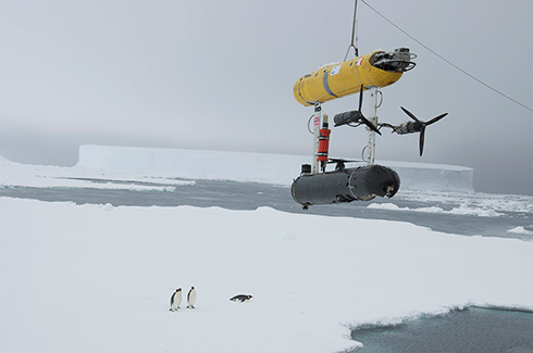
Deploying the Autonomous Underwater Vehicle, called SeaBED, in Antarctica Credit: Woods Hole Oceanographic Institution
|
The research results, published in the journal Nature Geoscience, will help scientists better understand dramatic sea ice changes predicted under various climate change scenarios.
Scientists currently use a range of techniques to measure sea ice thickness. Satellite observations measure large-scale thickness from space, but interpreting data accurately can be difficult due to snow cover. Measurements made on sea ice by drilling holes, together with visual observations from ships, are critical for building a more complete picture.
However, difficulties in getting access to thicker areas of sea ice leaves gaps in the data. With the new Autonomous Underwater Vehicle (AUV) known as SeaBED, scientists are filling this gap.
While most oceanographic survey instruments look downwards to the seafloor, SeaBED is fitted with an upward-looking sonar to map the underside of sea-ice floes. It operates at a depth of 20–30 metres and is driven in a ‘lawnmower’ pattern.
‘Putting an AUV together to map the underside of sea ice is challenging from a software, navigation and acoustic communications standpoint,’ says Hanumant Singh, an engineering scientist at the Woods Hole Oceanographic Institution (WHOI) whose lab designed, built and operated the AUV.
‘SeaBED’s maneuverability and stability made it ideal for this application where we were doing detailed floe-scale mapping and deploying, as well as recovering in close-packed ice conditions.’
Co-author, Dr Guy Williams from the University of Tasmania’s (UTAS’s) Institute of Marine and Antarctic, adds: ‘The full 3D topography of the underside of the ice provides a richness of new information about the structure of sea ice and the processes that created it.
‘This is key to advancing our models particularly in showing the differences between Arctic and Antarctic sea ice.’
The team deployed AUVs as part of two Antarctic cruises in 2010 and 2012. Three locations around the Antarctic Peninsula were mapped – the Weddell, Bellingshausen and Wilkes Land sectors, covering an area of 500,000 square metres, the size of 100 football pitches.
‘What this effort does is show that observations from AUVs under the ice are possible and there is a very rich data set that you can get from them,’ says Ted Maksym, a WHOI scientist and another co-author.
The research was carried out by scientists from Australia’s UTAS Institute of Marine and Antarctic Studies and Antarctic Climate and Ecosystem Cooperative Research Centre; from the US Woods Hole Oceanographic Institution (USA); and from the British Antarctic Survey (UK).
Source: UTAS

