

|
Published: 4 July 2011
Mapping the good earth
Soil is fundamental to crops. It provides the substrate that stores and provides water and nutrients, and the underground biology essential for plant growth. But as most farmers would attest, not all soils are equal. Scientists are collaborating to develop an online global soil mapping resource that will provide developing countries with more accurate information for managing land use, including food production.
|
|
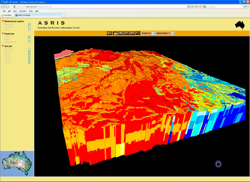
GlobalSoilMap.net will be used to predict soil properties (such as texture and soil carbon) for every 90 x 90 metre square across the world, down to a depth of 2 metres. This image shows how the variation of properties with depth could be displayed. Credit: CSIRO
|
CSIRO is leading the regional node of this project to produce the first detailed, three-dimensional digital map of the world’s soils.
The free online resource – GlobalSoilMap.net – is being developed by eight globally-distributed research nodes, and is coordinated through ISRIC–World Soil Information, an independent foundation based at Wageningen University in the Netherlands. It is supported globally by the Bill & Melinda Gates Foundation, and locally by CSIRO, the Terrestrial Ecosystem Research Network, the University of Sydney and the Australian Research Council.
Leading the Oceania Node is CSIRO soil scientist Dr Neil McKenzie. The Oceania node is a partnership involving science and environmental agencies from Australia, New Zealand, Indonesia and The Pacific Islands so far.
Dr McKenzie says that as soils are a finite resource, they must be carefully managed to help tackle big issues such as sustainably producing food for the world’s burgeoning population, storing freshwater resources and supporting natural ecosystems.
‘To address the challenges of food security and environmental sustainability, we need scientific information on the health of our soils to inform the steps that we take to manage our land and farming systems better,’ he says.
The Global Soil Map will provide users with vital information on key soil attributes, such as depth, density, moisture and nutrient capacity, salinity, level of acidity or alkalinity, and proportions of clay, sand and silt. The online resource will also provide new ways of viewing soil information, as well as computer models that will allow users to access best estimates of key soil properties worldwide, at depths of up to two metres in areas of 90 metres by 90 metres.
Through the partnership of research agencies and soil practitioners worldwide, scientists are establishing best-practice soil assessment techniques that can be used in all countries. Importantly, the project will also give many countries access to new technology and training.
Rain, erosion take their toll in Fiji
Mr Inoke Ratukalou, Acting Director of Land Resources Division and Secretariat of the Pacific Community, points out there is only one active pedologist (soil scientist) in the entire Pacific Islands region. There is also very little opportunity for students to get involved with soil science.
Mr Ratukalou says the lack of support for soil and landscape science and expertise, along with the continuing impact of erosion and climate change, mean the soil and landscape will continue to degrade.
‘In Fiji, we know that the climate is really changing,’ he says. ‘In the past, we’d have the hot and wet season and the cool and dry season. Nowadays, we don’t have cool and dry. We have rain that starts in January and goes to December.’
The change in rainfall – along with erosion of coastal zones due to storm surges, an increasing population, and communities cultivating crops on steep slopes – has put Fiji’s valuable soil resources under pressure. As the climate changes further, some crops could disappear from Fiji altogether.
|
|
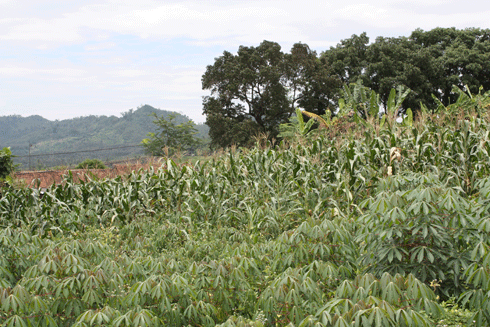
Cassava (foreground) and maize/corn crops (background), Indonesia. The country is the fourth largest producer of cassava – used for human and animal food, alcohol and biofuels – in the world. Credit: CSIRO
|
‘Many people assume that the land will always be there, even if they abuse it,’ Mr Ratukalou says. ‘This is a real problem, as unlike climate change and sea level rise – where you can see the effects – soil is often forgotten. We’re seeing great soil degradation, and yet good soil is crucial to our social security.’
As part of a partnership formed under the Global Soil Map project, the Landcare Research Institute of New Zealand has helped Fiji’s Ministry of Primary Industries’ Land Resources Planning Department digitise all of its soil maps. Soils across the country have been classified by physical and chemical traits, and Mr Ratukalou and colleagues are now working on a soil interpretation manual. The manual will be provided to extension officers – along with 70 crop profiles – allowing them to see which agro-ecological zones the crops grow best in.
‘Farmers will be able to identify the soils in their location and then work out if it’s the best soil for pawpaw or whatever crop,’ says Mr Ratukalou. ‘Accurate soil information is imperative to make the right decisions for appropriate food crops.’
‘That’s the beauty of this soil information and the GlobalSoilMap.net project,’ he adds. ‘Through their joint effort, the hundreds of researchers working on the project can help countries of all sizes access information that many countries likely would not have been able to gather or develop independently.’
Mapping to aid food production
With the need to increase food production, further soil mapping is critical, according to Dr Muhrizal Sarwani, Director of the Indonesian Center of Agricultural Land Resources Research and Development (ICALRD).
|
|
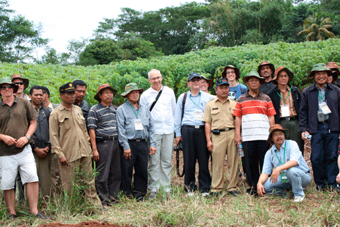
A recent Global Soil Map project workshop in Bogor, Indonesia, led by CSIRO’s Dr Neil McKenzie (centre). Credit: CSIRO
|
‘We need to map all [soils] to support all the activities that are going on, and for the decision makers to plan everything, like new plantations, farms, communities,’ he says.
As Indonesia is aiming to increase its rice production by five per cent, Dr Sarwani says that more accurate mapping will enable the government to locate land suitable for expanding rice and cropping areas. He is particularly interested in a recent global mapping technology development that enables scientists to integrate field sampling data with digital soil information and model key soil attributes.
Indonesia is currently researching the implementation of new technologies to reduce methane emissions from the nation’s vast areas of peat soil, which support important crops such as palm oil, rubber and food staples.
‘We are measuring carbon stocks and benchmarking how much is being released now,’ says Dr Sarwani. ‘Then we will measure emissions after we apply different treatments like changed water and fertiliser regimes. Using remote sensing, direct sampling and portable chromatographic and infrared scanning devices, we are able to measure things like carbon dioxide, methane and water-holding capacity.’
ICALRD researchers are hoping to establish which of the techniques will prevent methane production. The exercise will also contribute data and expertise to further develop GlobalSoilMap.net.
|
|
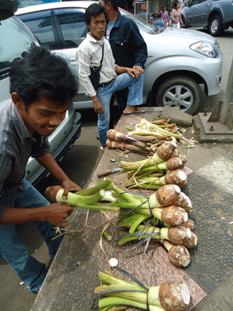
Locally grown taro on sale in Indonesia – the country sees soil mapping as critical to increasing its food production. Credit: Claire Harris
|
Through their work in the Oceania Node of the Global Soil Map project, Dr McKenzie, Dr Sarwani and Mr Ratukalou are committed to fostering regional and global collaboration of relevant government and scientific agencies.
‘The GlobalSoilMap.net project has the potential to develop new methodologies and a new paradigm for soil science, while telling the story of how important soil is to agriculture and food production,’ comments Dr Sarwani.
‘We hope that there will be more worldwide support for soils information, and that ultimately young people will get involved to ensure a sustainable future,’ adds Mr Ratukalou.
More information
Global Soil Map/CSIRO: www.csiro.au/partnerships/Global-Soil-Map.html
GlobalSoilMap.net: www.globalsoilmap.net

