|
Published: 16 April 2012
Climate-resilient restoration of box gum grassy woodlands
Box gum grassy woodlands are an iconic part of the eastern Australian landscape and once extended across large parts of inland south-eastern Australia. On trial sites on farmland in southern and central New South Wales, CSIRO is looking at ways of restoring these unique ecosystems to improve their resilience to a drying, warming climate.

|
|
Box-Gum grassy woodland at Mulligans Flat on the outskirts of Canberra. Credit:
Brett Howland
|
Box gum grassy woodlands are characterised by widely spaced eucalypts above a ground layer of native grasses and wildflowers. The trees are primarily white box (Eucalyptus albens), yellow box (Eucalyptus melliodora), and Blakely’s red gum (Eucalyptus blakelyi). Healthy box gum grassy woodlands support more than 400 plant species, and animals such as squirrel gliders, goannas, regent honeyeaters and bush stonecurlews.
|
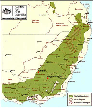
| Historical distribution of box gum grassy woodlands across South Eastern Australia |
However, the lower fertile foot slopes and flats that support these woodlands have also been the areas preferred for cropping, pasture, and infrastructure development. Widespread clearing, grazing, cultivation and fertiliser application have resulted in box gum grassy woodlands being nationally listed as an endangered ecological community.
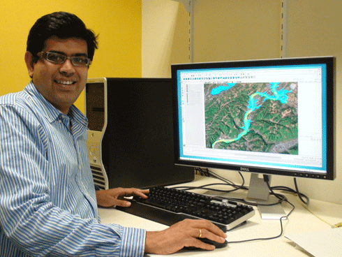
‘A huge amount of money has been invested in revegetation and restoration and increasing understanding of the status of ecosystems. However climate change makes the outcomes of these projects uncertain,’ says Dr Suzanne Prober of CSIRO’s Ecosystem Sciences.
With a focus on climate-resilient restoration, Dr Prober and team members Dr Saul Cunningham, Jacqui Stol and Melissa Piper, are looking at the functioning of soil in these woodlands.
‘Given predictions for a drying climate in south eastern Australia, the capacity of soils to capture and store moisture will become increasingly important for the success of revegetation efforts. We are targeting restoration of soil functioning in depleted native pastures, which are a common starting point for revegetation,’ says Dr Prober.
The trial sites are near Wagga Wagga, Cowra and Boorowa in New South Wales.
|
|
A member of the project team sows Eucalyptus melliodora seeds, Binalong, 2011. Credit:
CSIRO
|
The trial sites are areas that were grazed, often heavily, in the past, and have not had substantial fertiliser applications. Dr Prober explains that the low-input history of the sites is important given that too many soil nutrients, particularly phosphorus and nitrogen, are an even greater problem in maintaining a healthy woodland than too few. This is because high nutrient levels tend to favour exotic species, such as introduced pasture grasses, making them more competitive over the indigenous plants.
Compaction associated with grazing can reduce water infiltration and water storage capacity of the soil. Grazing can also reduce the quantity of perennial native grasses and forbs, which contribute to soil structure by providing year-round ground cover, and organic matter additions to the soil in the form of decaying vegetation.
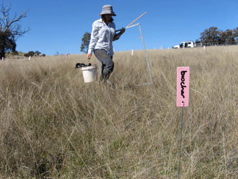
‘We are trialling five treatments to help increase soil carbon, soil biological activity, and soil water retention: biochar addition, soil aeration, phosphorus fertilisation, mulching, and sowing of native red leg grass (Bothriocloa macra), which is a good coloniser of harsh sites,’ says Dr Prober.
The biochar for the trials is being provided by Sydney Company Pacific Pyrolysis (PacPyro). Pac Pyro’s pilot plant recycles waste organics into biochar and bioenergy.
‘The biochar we are supplying to this project is low in nutrients and has a high stable carbon content,’ says Dr. Adriana Downie, Chief Technology Officer at PacPyro.
Most past biochar trials have involved application in cropping or horticultural contexts where it is incorporated into the soil: for example, in cultivation prior to sowing of the crop. The CSIRO project however, has needed to develop a way to apply the biochar with minimal disturbance to the soil, so as not to unduly disturb existing native grasses.

|
|
Applying biochar treatment. Credit:
CSIRO
|
The phosphorus treatment has been used as a comparison to mimic what might be a typical management strategy for improved pastures in the region. Dr Prober explains that while they expect the phosphorus may improve soil carbon and biological activity, it could favour exotic plants rather than natives.
It is clear that many box-gum grassy woodlands already have many champions among farmers in south eastern Australia. The Grassy Box Woodland Conservation Management Network, established in 1998, has 1500 landholder participants. The network works with organisations across 7 catchments (including the Murray, Murrumbidgee, Lachlan and Namoi) to provide field days, forums and workshops, as well as supporting on-the-ground works.
One of these landholders is Janice Schultz of Binalong. She and her husband Michael run a superfine wool and fat lamb enterprise on their property, and are members of the Harden-Murrumburrah Landcare Group (Binalong subgroup). One acre of their property is in the CSIRO trial.
Separately to the CSIRO project, Mr and Mrs Schultz have been involved with the creekline fencing and planting of indigenous trees, including box gums, and bushes around Binalong.
‘You definitely see improvements over the 10 years we’ve been involved. Before we started it was a sad sight in many of the areas. There was erosion on the steep hills and the banks of creeks were all grassed up,’ says Mrs Schultz.
‘Now, ten years on, we’re seeing higher bird numbers, and birds we haven’t seen before.’
|
|
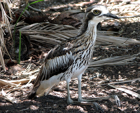
The bush stone-curlew (Burhinus grallarius) is still widespread and common in northern Australia but is listed as endangered across south-eastern Australia. Bush stone-curlews inhabit open grassy woodlands, with grey box woodlands being preferred habitat. Credit:
Drew Douglas. Rights: Licensed under a Creative Commons Attribution Non-Commercial License http://creativecommons.org/licenses/by-nc/2.0/deed.en
|
The CSIRO project is part of a larger Communities in Landscapes (CIL) project led by Landcare NSW and funded under the Australian Government’s Caring for Our Country program. CIL is an outreach program that aims to increase landholder engagement in land stewardship activities that benefit box-gum woodland landscapes.
Cowra farmer John Rankin who runs cattle and sheep on his property, is also a participant in the trial and describes the patch on his property that is being used as ‘box woodland with native understorey, but reasonably degraded from grazing. It’s native pasture country which hasn’t been fertilised and is probably very low in phosphorous and nitrogen.’
Mr Rankin is no stranger to conservation. As chair of the Cowra Woodlands Bird Group, he has been involved in many on-the-ground works helping to restore box gum grassy woodlands on local farms as bird habitat. On his own property, he has spent a great deal of time and effort establishing a rotational grazing system on some of the less-fertile areas. It aims to assist with the recruitment and persistence of native grasses, box gums, and other plants from box gum grassy woodland ecosystems. This system rests the pasture from grazing in spring to allow native grasses to set seed.
‘We’re finding that with a rotational grazing system we’re getting a much better regeneration of native pasture, and recruitment of grey box and yellow box, and we’re also finding that some of the scald areas [patches of land severely affected by salinity and therefore typically denuded of vegetation] are covering over with native herbs and grasses.’
Mr Rankin believes that two keys to unlocking more farmer participation in on-farm conservation are education and adequate remuneration for land stewardship.
‘Most people you meet are interested in conservation. But most people don’t actually have the knowledge required to carry it forward,’ says Mr Rankin.
‘The other important aspect with on-farm conservation is that people running farms have got to make money. Somehow or other, we’ve got to make the conservation of our flora and fauna a financial proposition for farmers.’
More information
Bringing Back the Box Gum Grassy Woodlands
Biodiversity in the Paddock: A Land Manager’s Guide
Communities in Landscapes Project