

|
Published: 2 May 2012
Imagining a greener future for Ningaloo
When we plan for the future, it helps to clearly imagine the alternatives – for example, the impact different development scenarios will have on the environment. Western Australia's Ningaloo coast has natural resources that fuel a major tourist industry. Scientific modelling can help us understand the combined impacts of tourism, offshore gas and mining, and climate change on this unique area.
|
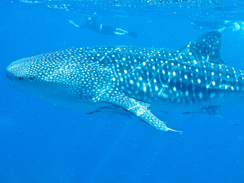
| For tourists, Ningaloo has become synonymous with whale sharks. Environmentally sensitive development will be essential in protecting the region’s unique and valuable ecosystems. |
Over the past decade or so, WA’s Ningaloo-Exmouth region has undergone a transformation. The economy of this once-sparsely populated pastoral area – its population is still only around 2500 – has diversified to include tourism and industrial development.
The high number of tourists – roughly 200 000 per year – is due to the region’s exceptional beauty. Ningaloo-Exmouth is adjacent to Australia’s largest fringing coral reef which stretches 300 km from Exmouth to Canarvon.
The reef is said to rival the Great Barrier Reef in terms of beauty and biodiversity, with hundreds of species of coral and reef fish, as well as marine turtles, dugongs and dolphins. The Ningaloo coast is also famous for its offshore ‘marine highway’ travelled by whales and whale sharks, which are now synonymous with the region.
This unique marine environment is offset by its stunning terrestrial ecosystems, such as those of Cape Range National Park.
Last year, the United Nations accorded World Heritage status on the 243 600-hectare Ningaloo Marine Park, making the region – already renowned for its snorkelling, SCUBA diving, recreational fishing and ‘swimming with whale sharks’ experiences – an even more attractive destination for international tourists.
Can the environment cope? While the Great Barrier Reef is also World Heritage-listed, the Ningaloo marine park area differs in that recreational areas are mostly close to shore and tourism is concentrated at coastal camping areas and towns during the winter months. This concentration of activities has led to some warning that the low-rainfall Ningaloo region is in danger of being ‘loved to death’.

|
|
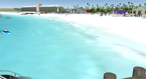
How a typical Ningaloo beach would look if the area remains relatively undeveloped. This scenario assumes current tourism operations and management regulations remain in place (i.e. beach camping dominates) and there is no petroleum, gas or mining resource sector development beyond 2007 levels. While this situation no longer exists, it is a helpful baseline against which to compare other scenarios. Credit:
Beth Fulton/CSIRO
|
Further, as is the case for north-west Australia as whole, natural resource management must contend with increasing industrial development, largely based around oil and gas extraction and mining.
For Ningaloo, the diversity of local activities – tourism, farming, fishing and oil and gas exploration – mean that development must be sensible and sustainable if the area’s natural resources are to be maintained.
Add the prospect of climate change impacts, and the range of possible futures expands even further. This is why scientific models, which offer credible projections of how things may play out over time, are an important part of the decision-makers’ toolkit.
Whether quantitative or qualitative, these models help us understand the interplay between human activities and ecological effects, identifying methods to foreshadow and mitigate negative impacts, and to make plans for preserving and sustaining ecosystems.
Our team at CSIRO worked with local residents, scientists active in the area, policy-makers, regulators and commercial operations (both tourist and industrial) in the region to develop a model of both the natural and human parts of the Ningaloo-Gascoyne system.
We used the model to simulate different futures, defined in terms of levels of climate change, industrial development and management regimes. We then examined the potential outcomes in terms of ecological, economic and social indicators.
The results show that some environmental assets are sensitive to changes in climate drivers. For example:
-
Sea turtles are sensitive to the loss of nesting beaches as a result of sea-level rise and inundation during extreme events.
-
The cumulative effects of recreational fishing pressure (there is little commercial fishing in the area) can impact the relative composition and abundance of the fish stocks.
-
Habitats in high-use areas are potentially vulnerable to degradation, even from ‘low impact’ activities like snorkelling and diving.
Alternative management can help mitigate these impacts. On the other hand, unconstrained use of the system (which includes a limited freshwater resource) by visitors and local residents at or above the levels recorded for 2010 is, according to the simulations, no longer possible without the threat of significant environmental impacts.
The simulations also revealed social and economic challenges, the solutions to which could put rising pressure on the environment. For example, the Exmouth area’s resident population is vulnerable to ageing and the local economy is at risk of stagnation.
To avoid this, the region will need to expand existing commercial initiatives, or develop new ones, although the latter option is currently constrained by available housing and labour.
However, such growth has costs, in terms of increased demand for housing, utilities and waste-handling. CSIRO models show that targeted growth can ameliorate impacts and provide more sustainable options – for instance, around employment, or around lifestyle and maintaining a healthy environment.
To take an example, a major expansion of the resource sector or the development of a resort would lead to a significant boost to the economy, road transport, population and demand for services and infrastructure. Unfortunately, this would come at the cost of a large environmental footprint: local fish stocks would drop by about 50 per cent, and demand for water would increase by more than 600 per cent.
|
|
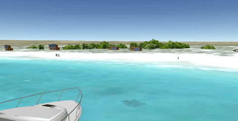
How a resort and retail development might look at Ningaloo. Little extra housing is provided beyond the resort, while urban-like development (on the scale of the existing community of Coral Bay, but largely hidden by extensive landscaping) has been allowed. Planned resource sector development is also assumed to occur in full by 2035. This form of development has, by far, the largest environmental and utilities footprint, especially if located on a previously undeveloped site. Credit:
Beth Fulton/CSIRO
|
In contrast, an eco-lodge development on the same location would lead to continual, low-level growth, mostly reliant on tourist markets with high per-capita spending patterns (for example, international tourists willing to pay a premium for a ‘wilderness’ experience).
This option would be associated with a much smaller environmental footprint. Moreover, if this is combined with modified recreational fishing regulations (e.g. the ‘wilderness fishing’ idea, where catch is limited to what you can eat that day) local fish stocks can grow compared to today, rather than decline, while the demand put on utilities like water would increase by less than 80 per cent in total.
Unfortunately, an eco-lodge development would still not release the region from social issues such as competition for limited dwellings by seasonal workers.
|
|
Simulations showing an eco-lodge option for a Ningaloo beach: Planned resource sector development is assumed to occur in full by 2035, meaning that there is a much higher density of pleasure craft and potentially recreational fishing, though whether this is accommodated by eco-lodges will likely vary depending on lodge regulations. Some large charismatic marine megafauna (e.g. large rays – shown here – although heavy use or repeated approaches could see their frequency of visitation drop) remain. Broader environmental impacts of development (e.g. higher numbers of road trains, shipping, etc) will not always impact more sheltered sites, so may not affect ambience at well-sited eco-lodges. Credit:
Beth Fulton/CSIRO
|
This is where another outcome of our project – the Ningaloo Destination Model (NDM), an applied planning tool that assesses a range of future scenarios for the Ningaloo Coast – comes in.
The NDM computer simulation tool can assist stakeholders to get a feel for the environmental and economic sustainability of different development options, assisting managers, businesses and communities to make decisions about tourism, and set and achieve goals.
They can determine the social and economic consequences of different tourism plans and developments, and the impacts of these on water, waste and power demand. The model can also be linked to an ecological model developed by CSIRO to assess the ecological impacts of different development pathways.
CSIRO scientist, Dr Beth Fulton, is an internationally recognised marine ecosystem modeller, having developed one of world’s most widely used whole-of-ecosystem models for the marine environment – Atlantis.
Find out more about CSIRO’s Ningaloo Collaboration Cluster

