

|
Published: 22 May 2012
Historic land survey leaves enduring legacy
Australia’s far north is a challenging place to conduct research at the best of times. A CSIRO-led project to survey these vast and remote lands in the years following World War II was ambitious in scope and methodology. But, the gamble paid off. Jen Morris explores the legacy of a remarkable scientific endeavour: the CSIRO Land Research Surveys.
|
|
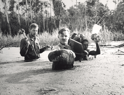
Survey team members wading through flooded swamp woodland near Malalaua airstrip, lower Tauri–Lakekamu area, New Guinea, 1966.
Credit: CSIRO Land Research Surveys Archive
|
Since the first European settlers staked their claims to Northern Australia, the Top End has been seen as the Wild West of agricultural and water resource development: an untapped frontier with unknown and possibly unlimited potential.
The desire to ‘open up’ Northern Australia has resurfaced on the national agenda in recent times. Former Prime Minister, Kevin Rudd, established the Northern Australia Land and Water Taskforce, who were charged with the task of exploring the ‘strategic potential for further land and water development in northern Australia’ with emphasis on agricultural development. In late 2011, the Federal Labor Government announced a $10 million plan to trial irrigation agriculture with water from two Gulf of Carpentaria waterways: the Flinders and Gilbert Rivers.
Behind the headlines, scientists from government agencies have been quietly working for decades in some of Australia’s most remote and inhospitable country, providing policy makers with data and analysis to inform decision-making about development in the top end.
Perhaps the most extensive and heroic efforts occurred in the aftermath of World War II, when CSIRO was charged with systematically surveying land resources in Northern Australia. The CSIRO Land Research Surveys began in 1946, and were expanded in 1953 to include Papua and New Guinea (PNG), over which Australia had a political mandate.
These historical surveys have proved groundbreaking in a number of ways. Much of the data has stood the test of time and is still being used today. A forward-looking ‘holistic approach’ was adopted: the surveys integrated ecological features, including vegetation geomorphology, hydrology and climate.
Policy makers also required the data on a useful scale, but despite the extensive resources deployed for the survey, the vast areas to be covered made detailed studies impossible. To meet the challenge, CSIRO scientists used a new method to describe and delineate land. Teams divided the survey areas into mapping units called ‘land systems’ – areas that show a recurring pattern of topography, soils and vegetation. According to Dr Neil McKenzie, chief of CSIRO Land and Water, this approach showed profound environmental insight: ‘It was a new way of looking at the landscape – a very integrated, ecological view.’
|
|
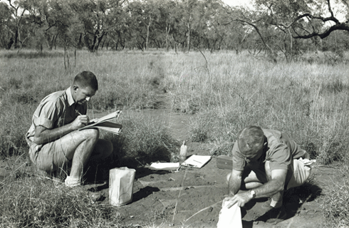
Soil sampling north of Ronlow Park Queensland, during the Nogoa–Belyando Survey, 1964
Credit: CSIRO Land Research Surveys Archive
|
Teams used aerial photographs, field work and laboratory analysis of specimens to map the boundaries of land systems, and generated detailed descriptions of each. These descriptions – incorporating features ranging from geology to hydrology, vegetation and wildlife – were published in 39 reports, now freely available online.
‘CSIRO were really the first ones to systemise that process,’ comments Noel Schoknecht, Science Leader (Soils) at Western Australia’s Department of Agriculture and Food.
Survey conditions
The survey teams faced extremely challenging environmental conditions, especially in PNG. There, teams had to travel through very rugged and mountainous terrain; almost no roads served the country’s interior. Before the introduction of helicopters in the mid 1960s, teams accessed survey areas on foot. Working in a time before GPS technology, they were guided only by maps that were often outdated, unreliable and incomplete.
Survey teams consisted of around six scientists, accompanied by support staff ranging from photographers to cooks.
‘It was a huge logistical exercise,’ says CSIRO Fellow Gael McAlpine, who is researching the history of the PNG surveys.
‘Food and supplies were dropped by air at supply points, which the team would reach at predetermined times.’
|
|
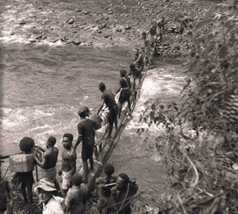
Crossing the Mubi River at Mendi–Tari, New Guinea, 1961
Credit: CSIRO Land Research Surveys Archive
|
Local political tensions posed a potential threat, so survey teams were often accompanied by a PNG police officer. Many Papua New Guineans recruited from local villages also took part as field assistants, carriers and support staff.
The legacy of the surveys
Using survey information, field stations – including one at Katherine – were set up in areas determined to have agricultural potential. The trials carried out at the stations helped shape modern-day farming in Northern Australia’s notoriously difficult conditions. Crops trialled included peanuts, sorghum and cotton.
‘Many of the crops failed,’ says Dr McKenzie, ‘and that was a really important part of the whole process.’
Despite decades of technological and scientific advancement, the land surveys remain relevant.
‘Here we are, over fifty years after the survey, and we’re still using that work...I don’t think there have been many areas of work where there has been that enduring legacy,’ says Dr McKenzie.
On one level, that legacy is methodological.
‘Everything, from how we use digital elevation models to geographic information systems, has a connection back to the early work done in the land systems surveys,’ explains Dr McKenzie.
Visiting international scientists spent time with survey teams in the field, and many international governments and agencies subsequently adopted the land systems method. Australia’s role in driving reform in land resource assessment culminated in a major international Land Evaluation Congress held in Australia in 1968.
On another level, the information itself is a legacy.
‘A really good-quality land system survey can be used time and time again,’ says Dr McKenzie.
|
|
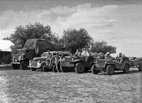
Survey team and vehicles near Anthony lagoon, Northern Territory, 1948
Credit: CSIRO Land Research Surveys Archive
|
Sixty-six years on, the survey data continues to have many – often novel – applications. In 1982, it was used to develop the sampling framework for PNG’s National Nutrition Survey. In Western Australia, land survey data are still being used to inform land lease valuation, feral animal control strategies and expansion of the Ord River Irrigation Scheme, among many other uses.
Infrastructure resulting from the surveys also remains crucial. For example, in 1986, the PNG Resource Information System (PNGRIS) was established using original survey data. Most recently updated in 2008, PNGRIS allows easy electronic storage, access and analysis of ecological data. More than 86 per cent of Papua New Guineans currently rely upon what they personally grow for subsistence and supplementary income. This makes PNGRIS a vital reference for research and policy making regarding village-based agriculture, cash cropping, forestry management and conservation.
Building on the legacy
Ongoing efforts are building on and improving the original survey information.
‘[The survey] process, with some improvements, is still going on today,’ says Mr Schoknecht. For example, distortions from plane movement and a lack of known landmarks to use as reference points with aerial photographs led to mapping errors in the original surveys.
Across the 31-year survey period, the metric system took root, technology advanced, and mapping conventions changed. So too did classification conventions for soil, vegetation and land systems. Consolidating and comparing information across survey reports is therefore difficult, and efforts are being made to rectify this. In December 2011, the Western Australian Department of Agriculture and Food compiled, clarified and built upon original CSIRO data to publish one harmonious report on the Kimberley’s land systems.
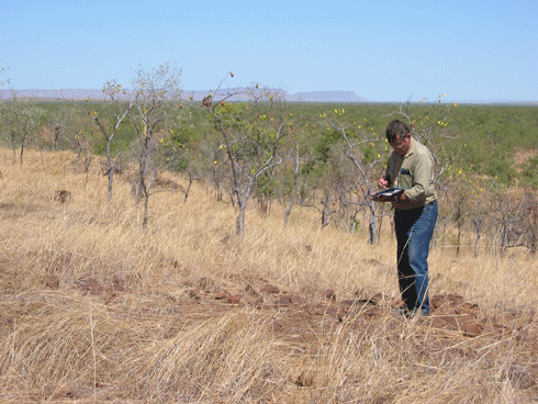
|
|
Alan Payne, former Rangelands Advisor with Department of Agriculture and Food, Western Australia (DAFWA), collecting survey data on the rocky basaltic slopes of Frayne Land System, East Kimberley, 2003 Credit: Photo by Noel Schoknecht, DAFWA
|
The development of Northern Australia is now firmly back on the national agenda. Yet, environmental awareness has also fostered a new potential use for the data – as a reference point for assessing the impact of changes such as land clearing. The surveys’ relevance to this modern tug-of-war between developmental ambition and environmental concern highlights Dr McKenzie’s view that ‘collecting the scientific and land resource information to try and guide decision making in land use was far-sighted’.
More information
Sustainable Development for Northern Australia: a comprehensive science review

