

|
Published: 15 April 2013
Is Shark Bay shifting from temperate to tropical?
Scientists in Western Australia warn that the future of one of Australia’s most extraordinary temperate seagrass ecosystems – the iconic Shark Bay – may be under threat from warmer seas, heavier floods and sea-level rise associated with climate change.
|
|
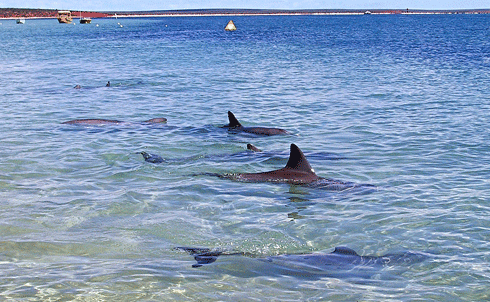
The dolphins of Monkey Mia have made Shark Bay famous, but this unique marine ecosystem, with its dugongs and other plant and animal life could look very different in future from climate change impacts. Credit: cskk via flickr under CC BY-NC-ND 2.0 licence
|
Tourists prize Shark Bay for the dolphins of Monkey Mia or Hamelin Pool’s bizarre ‘living fossils’ – stromatolites, which are living colonies of primitive blue green algae established around 3500 million years ago. For marine biologists and environmentalists, however, Shark Bay is also home to the world’s largest seagrass bank.
The Wooramel seagrass bank – named for the Wooramel River, which feeds nutrient-laden sediment into the bay – stretches for 1030 sq km. This vast underwater meadow includes 12 species of seagrass – more species than any seagrass ecosystem in the world. This habitat provides food and shelter to a diversity of marine life, from invertebrates and fish, to foraging dugongs and sea turtles.
But how might this World-Heritage listed ecosystem fare in the future, in a changing world?
Nature is already providing some clues. In December 2010, the area experienced its biggest flood event on record, with over 200 mm of rain in a single day recorded in the nearby town of Carnarvon. During the floods, the Wooramel River dumped large volumes of freshwater and sediment onto the seagrass beds.
Soon after, in February 2011, scientists noticed that seawater temperatures in the seagrass bank were among the highest recorded in the region, with mean temperatures of around 29°C. In fact, an extreme ocean heatwave at the time resulted in temperatures that were 2–4°C above the long-term average averages for that part of the WA coastline during late summer.
The occurrence of the two extreme weather events – flooding and ocean warming – within the space of months gave researchers an opportunity to see how predicted changes in climate under global warming, including sea level rise, might impact on Shark Bay’s seagrass ecosystems.
|
|
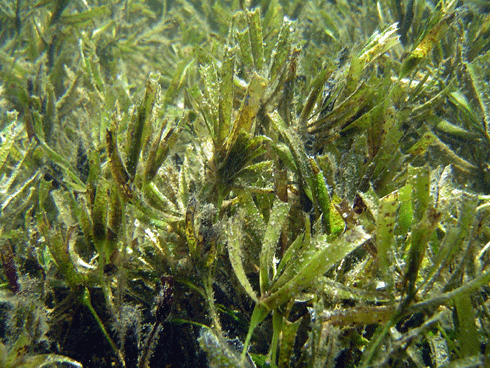
A healthy meadow of Amphibolis antarctica, Shark Bay’s predominant, temperate seagrass. Credit: M. Vanderklift
|
A collaborative team from CSIRO, the University of Western Australia, and the Florida International University began monitoring the impacts of the two events. Scientists made two major field trips in 2011 and late last year published a ‘Caring for Our Country’ report on their findings.
CSIRO scientist Dr Mat Vanderklift, a co-author of the report, says seagrasses are particularly vulnerable to climate change impacts because they occur in shallow subtidal and intertidal environments, where heatwave and flood impacts are more pronounced than in deeper waters.
Researchers already know that turbidity and light reduction is a major driver of seagrass loss worldwide, as suspended sediment blocks out the sunlight required for photosynthesis. At Shark Bay, prevailing winds swept the Wooramel River’s flood plume many kilometres north of the mouth of delta at the time of the 2011 flood event, contributing to visible seagrass dieoff up to 15 km away from the river’s mouth.
‘Turbidity from the sediments was visible far out into in the waters of Shark Bay for months after the floods receded,’ commented Mat.
In 2011, the WA research team observed widespread defoliation of the temperate seagrass Amphibolis antarctica – the most widespread canopy-forming seagrass in Shark Bay. They proposed that, while this defoliation was primarily correlated with distance from the Wooramel River delta – a measure of the flood plume extent – the combined effects of higher turbidity and temperatures resulted in greater defoliation than either effect alone.
Earlier laboratory experiments elsewhere had already shown that fewer A. antarctica seedlings survive in seawater temperatures above 25°C, with significant decline occurring above 30°C. Temperature thresholds for the tropical seagrass Halodule uninervis, however, are higher – above 30°C. This would explain why A. antarctica fared worse in the heatwave than H. uninervis – in fact, says Mat, the WA study concludes that in warming seas, tropical species like H. uninervis may replace temperate ones like A. antarctica as the dominant seagrasses in Shark Bay.
|
|
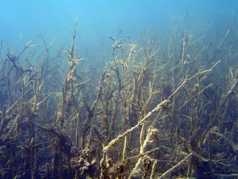
A dying stand of A. antarctica, showing turbidity and residue from the 2010-11 flood plumes. Credit: M. Vanderklift
|
The scientists also warn that predicted sea level increases of around 7 cm under climate change might lead to a salinity drop in the hypersaline Hamelin Pool, with results that, at the moment, are difficult to predict. (Interestingly, the rise in sea level may also reduce light levels in the existing seagrass meadow, impacting productivity.)
Why does all this matter? Seagrass meadows provide critical ecosystem services in the form of nutrient recycling, and food or habitat for marine mammals, fishes, birds, turtles and invertebrates. Globally, seagrass loss rates are comparable with those reported for mangroves, coral reefs, and tropical rainforests, placing seagrass meadows among the most threatened ecosystems on earth.
While little can be done about the future impacts of global warming – sea level rise, increased temperatures and more intense flooding – on Shark Bay’s seagrasses, Mat Vanderklift says that introducing measures to stabilise soils in the area may help reduce levels of turbidity in future flood plumes from the Wooramel River.
|
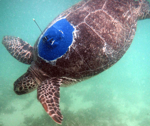
Green and loggerhead turtles are found in Shark Bay near their southern limits. Further north, in the Ningaloo Coast World Heritage Area off WA, a group of scientists led by Dr Mat Vanderklift is capturing and tagging green sea turtles to gain a better understanding of sea turtle ecology. |
|
|
A tagged turtle released at Ningaloo. Credit: M. Vanderklift
|
‘This is the first time turtle tagging studies of this kind have been conducted in the Ningaloo area,’ said Mat. |
‘Understanding where the turtles forage for food and how far they roam will provide invaluable information for ongoing management of these iconic animals in this World Heritage Area.’ |
Since February, Mat and his team have fitted 17 green sea turtles with acoustic tags which track the movement of the turtles as they pass by specialised listening stations in Mangrove Bay. |
Another two turtles from the same area have been fitted with satellite tags. Each time the aerial on the tag breaks the sea surface a signal is sent to a satellite and used to pinpoint the turtle’s position. |
The tags, attached to the turtle’s carapace (or shell), will give scientists an insight into the range and foraging patterns of these threatened marine reptiles. In addition, scientists are using remote underwater video to observe actual turtle behaviour. |
‘So far we have looked at more than 140 hours of video and have found that turtles tend to spend quite a lot of time in seaweed patches in the lagoon during the day,’ said Dr Vanderklift. |
Local students from Exmouth Primary School are getting behind the turtle tagging study. You too can become a virtual marine scientist and follow the turtles’ tracks in near-real time here. |
The turtle tagging project is a partnership between CSIRO, the WA Departments of Environment & Conservation (DEC) and Fisheries (DoF) and the Cape Conservation Group and is supported by the Commonwealth Government through Caring for Our Country funding. |

