

|
Published: 20 May 2013
Satellite imagery helps track tree-cover and carbon
Technology developed by CSIRO that makes use of satellite data to provide the most detailed maps yet of changes to Australia’s forest and land-cover is enabling more accurate measurements of the carbon emissions prevented through preserving forest or replanting cleared land.
|
|
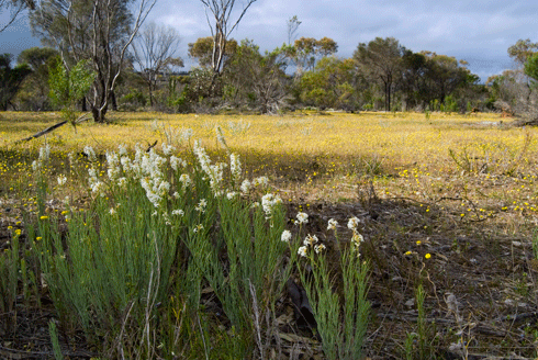
Chereninup Creek Reserve, a property in south-west WA owned by Bush Heritage Australia, is part of the Gondwana Link project. Credit:
Bush Heritage Australia
|
While some may think Australia has been slow to embrace the carbon economy, in fact we were years ahead of our time in the late 1990s, having developed the world’s first scientifically-based carbon accounting system for estimating land-cover carbon emissions.
A key component of this national carbon accounting system has been the packaging and analysis of satellite imagery showing changes to land-cover over many years. The end-product is a series of maps, created by CSIRO and the Department of Climate Change and Energy Efficiency, showing vegetation change over time, and at a fine scale, for the entire Australian continent.
The extent, time-scale and detail of the imagery assembled and processed have helped make our National Carbon Accounting System Land-Cover Change Program (known as NCAS-LCCP), the largest, and most intensive land-cover monitoring program in the world.
NCAS-LCCP is currently based on more than 7000 Landsat satellite images at a resolution of 25 metres (1 pixel per 25-square-metre quadrant), for twenty ‘epochs’ from 1972 to 2012. The system is updated annually.
The image sequences can be used to monitor changes in vegetation cover related to factors such as land-clearing, fire or disease. Natural resource managers call this enhanced capability ‘trends analysis’.
‘Forests and native vegetation usually appear static on maps. In fact these areas can be incredibly dynamic due to factors such as climate, fire, land uses such as grazing, and pests and diseases,’ explains Jeremy Wallace of CSIRO.
‘If you’re a conservation agency responsible for managing and improving the condition of a landholding, then these changes are exactly what you are interested in.
‘You’ll be particularly interested in what’s happened since you took over, compared to what’s happened before. Trends products can inform that question in a way which has been previously impossible.’
Innovative applications that natural resource managers have developed using NCAS-LCCP imagery include software being employed in landscape connectivity projects in southwestern WA ; a trends analysis for Shark Bay, WA; and a National Forest Trends Index.
VegMachine and landscape connectivity
VegMachine software , developed by CSIRO and funded by Meat and Livestock Australia, packages decades of monitoring data for vast tracts of rangeland into simple maps, graphs and reports. These show how land-cover has changed at specific locations, and how these changes compare to local benchmarks.
While VegMachine was designed for use by farmers and graziers at the property-scale, it has also been adopted by conservation agencies for use at a regional-scale.
In Western Australia, the aim of the Gondwana Link project is to connect the forests of southwestern WA around Fitzgerald River, with the Great Western Woodlands further east, around Kalgoorlie and the Stirling Ranges.
This large landscape-scale rehabilitation and revegetation project is supported by a range of conservation agencies including Bush Heritage, Greening Australia and Nature Conservancy. Its scale presents a constant challenge to those monitoring changes.
‘VegMachine lets us quickly and easily get a snapshot of vegetation change over the last two decades just in one piece of software,’ says Angela Sanders, Bush Heritage Australia’s ecologist for the Gondwana Link project. ‘You can do it in GIS, but it’s way beyond the capacity of most GIS operators.
‘We can fairly accurately pinpoint the onset of disturbances, such as fire and clearing. It would otherwise take you a long time to sift through all the relevant aerial/satellite images to pinpoint the date of disturbances.’
VegMachine helps scientists prioritise on-ground monitoring, making it more efficient and cost-effective.
‘We have a set of monitoring sites across remnant vegetation, revegetated paddocks, and areas that are regenerating naturally,’ says Ms Sanders.
‘We use VegMachine to identify stable versus declining versus improving vegetation areas. Then we “ground truth” [collect on-ground data to ensure it correlates with VegMachine findings] them.
‘We monitor the declining and improving sites every two years, but only monitor the stable sites every five years.’
In Queensland, VegMachine is used extensively by two natural resource management (NRM) bodies – the Fitzroy Basin Association and the NQ Dry Tropics, both funded by the Queensland and federal governments. Terry Beutel from the Queensland Department of Agriculture Fisheries and Forestries says VegMachine is often used to assess funding applications by landholders to NRM bodies.
‘For example, when a producer applies for funding to improve resource management, NRM groups can use VegMachine as part of the assessment process to work out where they’ll get the best return on investment.’
Visualising change around Shark Bay
Shark Bay, midway along Western Australia’s Indian Ocean shoreline, is a world heritage conservation area and home to the world’s largest seagrass bank. One if the bay’s landmarks, Dirk Hartog Island, has recently become a national park.
The main threats to the land around Shark Bay are overgrazing by domestic and feral animals, particularly goats, and the invasion of exotic grasses such as buffel (Cenchrus cilaris). Consequently, regional scientists and land managers are keen to monitor the impact of conservation measures such as destocking and feral animal control on vegetation condition. (Turbidity from soil particles in river flood plumes is one of the factors causing a decline in the bay’s seagrass meadows.)
Scientists used the NCAS-LCCP image archive to create vegetation trend images for the region. Jeremy Wallace says much of the information conveyed by these images was new to them, despite the considerable conservation efforts that have been made in the area.

|
|
Shark Bay region showing land-cover trends from 1988–2004.Different colours indicate different cover trends: red = declining, blue = increasing, black = stable, green = loss followed by recovery, yellow = loss followed by partial recovery. The map shows that an area south-west of the Peron Peninsula has suffered dramatic vegetation decline since the year 2000 (yellow and red). Subsequent inspections of this area revealed that the cause was overgrazing by goats. Credit:
Wallace J, Behn, G & Furby S (2006) Vegetation condition assessment and monitoring from sequences of satellite imagery, Ecological Restoration and Management Supplement 1 )
|
Identifying subtle changes to forest cover
While the current NCAS-LCCP is used to monitor permanent forest and land use changes, such as clearing and reforestation, it was not designed to track more subtle changes. A new product, the National Forest Trends index (NFT) has been developed for this purpose.
With the Australian Government having committed to a second round of the Kyoto Protocol to run from 2013-2020, the nation is required to reduce its greenhouse gas emissions by at least 5 per cent compared to 2000 levels by 2020.
Under the second-round Kyoto Protocol, carbon emission changes from forest management decisions, such as thinning, also need to be included in carbon budgets. This makes the NFT a very useful carbon accounting and monitoring tool for use under the UN’s REDD+ scheme (Reducing Emissions from Deforestation and Forest Degradation). The scheme has seen a number of demonstration projects under way, such as one in Indonesia’s Kalimantan peatlands . The project is a partnership between Australia and Indonesia.
‘We’re particularly interested to locate and quantify processes related to forest thinning – as a result of selective logging, low intensity fires, drought or disease – as well as thickening [due to recovery from disturbances],’ says Jeremy Wallace.
‘Quantifying the carbon changes is a modelling exercise. The NFT provides fundamental evidence of the areas and timing of forest changes, which are critical inputs to carbon models.’
The NFT products and the VegMachine software provide a model for how the wider community can access vegetation monitoring information. Mr Wallace is hopeful this will drive continued innovation in land-cover monitoring software. The really good news is that long-term archives of Landsat data over Australia will, in the near future, become freely available online.

