|
Published: 17 December 2013
Cities as refuges for species on the brink?
When we conjure up images of animals in temperate cities, we tend to think of pesky creatures like pigeons, cockroaches, Indian mynas, English sparrows, crows (or ravens), rats and mice. Elsewhere, city dwellers may encounter geckos, monkeys, raccoon-dogs and baboons.
|
|
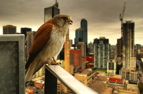
While some wild animals like the Nankeen kestrel (above) can adapt to urbanised landscapes, others, including threatened species, can’t. One solution is introducing more native landscapes to cities, to provide food and shelter for species in need of a refuge. Credit:
Jes Mugley CC BY-NC-ND 2.0
|
In all of these cases, the organisms have adapted and thrive due to the profusion of suitable habitats and resources provided by human settlements.
With an increasing human population and urban development intensity, ecologists and conservationists globally are gravely concerned about organisms able to adapt and thrive in human-dominated landscapes flourishing at the expense of those organisms that can’t – with the result that the latter will decline and eventually go locally extinct.
On the other hand, we’ve seen examples of iconic ‘wild’ creatures that have continued to inhabit urban and peri-urban ecosystems – peregrine falcons, bears, foxes, coyotes, deer, hedgehogs, koalas, kangaroos and microbats, to name a few. The news and scientific literature abound with examples of unfortunate interactions between such wild animals and people around the world.
For example, in his blog post, ‘Living with Bears: A Continuing Challenge in Alaska’s Urban Center’, Alaskan nature writer, Bill Sherwonit, discusses the increasing interactions between wildlife and urban dwellers living adjacent to wild lands in Anchorage, Alaska. I support his message that we need to increase urban dwellers’ awareness of the need try to live harmoniously with these wild animals.
In their efforts to create green, healthy and resilient cities and towns, decision makers – such as scientists, conservationists, architects, designers, planners, engineers, landscape architects, land managers and teachers – have an obligation to create urban ecosystems that will support a diversity of organisms. After all, these life forms are part of our natural heritage.
Research we have conducted at the Australian Research Centre for Urban Ecology (ARCUE) over the last decade leads me to believe we can move beyond living with a limited pool of urban-adapted species in our cities. How? By intentionally creating urban ecosystems that provide habitat and resources for a diversity of organisms.
One of our projects in particular examined the expanding range of the nationally threatened grey-headed flying-fox (GHFF, Pteropus poliocephalus) into Australian cities and towns. The results convinced us that we have the knowledge and skills to make cities around the world refugia for a diversity of organisms – including threatened species.
Humans vs flying-foxes
Over the past two decades there has been increasing interaction between humans and flying-foxes in Australia, most likely due to a combination of cities and towns expanding into their range, but also because of flying-foxes establishing new ‘camps’ within areas populated by humans.
There are some 11 species of flying-foxes in Australia, found primarily in the northern and eastern coasts of the continent. Grey-headed Flying-foxes are megabats (Megachiroptera) that live in roosts (called camps in Australia) ranging from tens of animals up to 200,000 individuals. They are commonly found along the eastern seaboard. Two of Australia’s major urban centres, Brisbane and Sydney, are home to ancient GHFF camps.
Up close and personal, GHFFs are big. It is one of the largest megabats, and invidividuals range in weight from 600 to 1000 g, with a wing span of up to a metre. I have heard locals refer to them as chihuahuas with wings!
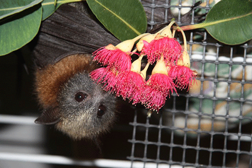
They are also long-lived, with an average reproductive age of 6–10 years. GHFFs are social animals that can forage up to 50 km for food at night, then congregate in pre-established camps in the morning. They primarily eat fruits and nectar from a variety of trees, but especially enjoy eucalyptus blossoms.
|
|
A grey-headed flying-fox in captivity eating pollen and nectar from a eucalyptus blossom. Credit:
Rodney van der Ree
|
GHFFs are critical to Australian forest ecosystems because they play a major role in pollinating trees and dispersing seeds in native hardwood forests and rainforests. They are listed as threatened under Australian Commonwealth law and are considered ‘vulnerable’. Their numbers have significantly declined over recent decades as a result of loss of feeding habitat and traditional camp sites due to deforestation.
Unfortunately, GHFFs carry several serious diseases that threaten humans and other animals. The two most dangerous are the Australian bat lyssavirus (ABL), a virus closely related to rabies, and Hendra virus, which is passed to horses and then from horses to humans. To date, there have been four human fatalities attributed to this virus in Australia.
Melbourne: the stopover that stayed
In Melbourne, GHFFs have been recorded occasionally passing through the city since 1884. The first year-round camp was established in 1986 at the Royal Botanic Gardens (RBG). Over the following 17 years, the camp grew exponentially, from 10–15 individuals that remained year-round in 1986, to nearly 30,000 individuals in March 2003.
The Royal Botanic Gardens, which was established in 1846 soon after the city of Melbourne was founded, is a much-treasured cultural asset that receives between 1.5 and 2 million visitors a year. It was obvious to nearly everyone that 30,000 GHFFs camping in the Botanic Gardens during the day had negative impacts (noise, smell, plant damage, etc.) on the plant collections, gardens staff and visitors.
As the Director of the Australian Research Centre for Urban Ecology – a division of the RBG – I found this to be a challenging research and management predicament. Something had to be done to reduce the impacts of the GHFFs on the RBG. At the same time, however, the health and welfare of the nationally threatened GHFF population needed to be maintained.
Ultimately, the solution to this conundrum emerged from the combination of solid scientific knowledge of the issues (ie the ecology of the flying-foxes and the gardens’ environment) and a strong working partnership with the local GHFF management authority which, in our case, was the Victorian Department of Sustainability and Environment.
To develop a solution, we needed to address two primary questions:
-
Why did the flying-foxes migrate over 400 km from their nearest existing camp to establish a new permanent camp in Melbourne?
-
Was there scope for moving the camp to a suitable nearby habitat with less public access without negatively impacting on the health and welfare of the population?
Initially, the popular belief was that the GHFFs moved to Melbourne because of the destruction of native habitat as a result of the expansion of orchard and crop lands, and sprawling suburban development. Upon closer examination it was clear that most of this land-use change occurred more than 50 years ago. If this was the driving factor behind the GHFFs’ move to Melbourne, the relocation should have occurred much earlier.
The other primary reason for such ‘wild creatures’ migrating to urban areas is the availability of much needed resources, especially food.
So, what had changed in Melbourne?
Prior to European settlement, Melbourne supported only three species of plants that were important food resources for GHFFs. In the 1970s, there was renewed interest in cities and towns throughout Australia to plant native species. Melbourne saw a significant increase in the number of eucalypts and other trees, such as Morton Bay figs, from around Australia, planted along streets and in parks and gardens.
From our analysis of Melbourne’s street trees in early 2000, we found an additional 87 species that provided sustenance for GHFFs and other tree-dwelling species such as lorikeets and possums. Not only were there more types of food resources available, because the trees came from different parts of the country, they had different life cycles. This provided blossoms and fruits throughout the year.
This point is especially notable – never before in the history of this species has there been an abundant year-round availability of food resources in a limited geographic location. Because humans cultivate and water these urban plants even during severe Australian droughts, cities provide an unprecedented food resource for many animal species. We feel, in part, this is why GHFFs now call Melbourne home.
Once we understood this, we needed to develop appropriate techniques to manage the GHFFs in a way that would protect them from further harm while limiting their impacts on urban dwellers.
Using good science and a lot of help from volunteers, we were able to move the GHFF camp out of the RBG. In 2003 over a period of several weeks, we herded the flying-foxes out of the RBG to a more secluded park along the banks of the Yarra River some 5 km away, without any harm coming to the GHFFs or the public. We accomplished this by primarily playing loud sounds, which we had especially developed to excite GHFFs, from speakers attached to garden utility vehicles.
This ‘new’ Melbourne GHFF camp has remained intact in this location for the last 10 years. During that time, the techniques we developed to manage urban GHFF populations have been adopted in other cities and towns in eastern Australia.
|
|
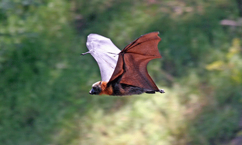
A grey-headed flying-fox from the new camp along the Yarra River, Melbourne. Credit:
Ian Kitchen
|
In recent years, GHFFs have established completely new camps in other cities in New South Wales, Victoria and South Australia. We believe that the replanting of urban forests in Australia with native species have provided a totally new resource for many Australian birds and mammals, but especially the threatened GHFFs.
As land-use change, drought and fires create an increasingly unpredictable food resource for these species, cities and towns now provide abundant and stable food resources for the future.
The take-home message from our Australian experience is that everyone should seriously consider which plant species are cultivated in cities and towns around the world. It is possible to plant species that will, in the future, provide valuable resources for threatened and endangered species.
Mark McDonnell is Director of the Australian Research Centre for Urban Ecology, Melbourne, and has athored or co-authored over 100 scientific papers, reviews, book chapters, reports and articles. His most recent co-edited book published by Cambridge University Press in 2009, Ecology of Cities and Towns, assesses the current state of urban ecology research around the world and identifies future challenges and opportunities in applying research to create resilient and liveable cities and towns. This article first appeared in the blog, The Nature of Cities.
More information
Shukuroglou P and MA McCarthy (2006) Modelling the occurrence of rainbow lorikeets (Trichoglossus haematodus) in Melbourne. Austral Ecology 31, 240–253.
van der Ree R, MJ McDonnell, Temby ID, Nelson J and Whittingham E (2005) The establishment and dynamics of a recently established camp of flying-foxes (Pteropus poliocaphalus) outside their geographic range. Journal of Zoology 268, 177–185.
Australian Government Department of Environment, the Grey-headed Flying-fox, species profile.