|
Published: 22 December 2014
Explainer: the RV Investigator’s role in marine science
We know more about the surface of the moon than we do about our deepest oceans, and only 12 per cent of the ocean floor within Australia’s Exclusive Economic Zone has so far been mapped.
|
|
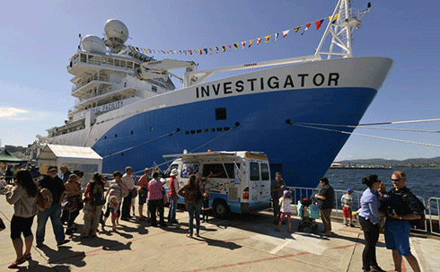
RV Investigator at sea – it has just been commissioned in Hobart. Credit: CSIRO
|
The reason for this is that we haven’t had access to the technology to get the job done, but things are about to change.
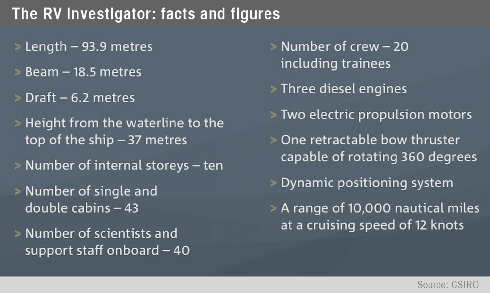
Australia’s new 94-metre $120 million research vessel (RV) Investigator has just been commissioned in Hobart. It’s replacing the RV Southern Surveyor which had been in service for more than 40 years and was decommissioned and sold earlier this year.
With the RV Investigator we will now be able to map the ocean floor to any depth, search for resources, better understand our fisheries, collect weather data 20-kilometre into the atmosphere and much more.
With 40 scientific berths, a range of approximately of 10,000 nautical miles (about 18,520 km) in a single voyage and the extensive list of capabilities, RV Investigator heralds a new era in marine and atmospheric research for Australian scientists and their international collaborators.
The ship is impressive, with about $20 million worth of scientific equipment, capable of enabling biological, oceanographic, geological and atmospheric research.
The magnitude of the change from the RV Southern Surveyor means the farthest reaches of the three major oceans that surround us are no longer impenetrable. In the past, research vessels have travelled from Europe and the US to uncover what’s going on in our own backyard.
Australia’s oceans are estimated to contribute $42 billion annually to our economy through marine industries such as aquaculture, wild fisheries, recreational fishing, and offshore oil and gas exploration and extraction and this is expected to increase to more than $100 billion in 10 years.
RV Investigator is owned by CSIRO and managed by the Marine National Facility, which itself is managed by an independent steering committee. Most importantly it is truly a national facility with sea time available to all Australian marine scientists.
Silent running
CSIRO undertook a rigorous procurement process and Teekay Holdings Australia was awarded the contract to design, build and commission the new ship. It was designed by RALion from the US and Canada, and was built by Sembawang Shipyard in Singapore.
RV Investigator has been specifically designed to an international maritime classification called DNV-Silent-R. Achieving this classification puts RV Investigator in the realms of being one of the quietest vessels in the world.
Radiated ship noise interferes with acoustic signals so by building a quiet ship we will be able to maximise the performance of the equipment to be used to monitor the marine ecosystem, and map the seafloor and sea bed.
|
|
|
The hull shape was designed using computer-based fluid dynamics to ensure any bubbles formed by the hull moving through the water (bubble sweep-down) don’t interfere with the acoustic equipment.
The design and the capability is so impressive that RV Investigator was named as one of the top 13 ship building projects for 2013, by IHS Maritime 360, amid a field of some 2900 projects globally.
So what sort of research will be carried out on-board the RV Investigator?
Biological research capabilities
The oxygen in every second breath you take has been created by phytoplankton through ocean photosynthesis.

|
|
RV Investigator is ready to explore the Southern Ocean after months of sea trials. Credit: CSIRO/Max McGuire
|
The oceans are effectively the world’s lungs, the currents are the veins moving nutrients around and the biological oceanographers are the doctors monitoring blood pressure and overall health.
Marine biologists on RV Investigator will be able to study ocean life, including phytoplankton, sea cucumbers, worms, crabs, jellyfish, squids, sponges and algae as well as commercial fishery species like southern bluefin tuna.
They will also collect samples to better understand the life cycle and ecosystems of marine plants and animals.
Oceanographic research capabilities
Oceanographers seek to understand the dynamics of the ocean and observe changes across seasons and over decades to better understand weather, climate and how changes impact fisheries and other marine life, offshore infrastructure and coastal developments.
To study large ocean processes, scientists deploy moorings on the ocean’s surface and below the waves. These moorings enable scientists to put scientific equipment into the ocean to continuously collect data from sensors over a period of one to two years.
On board RV Investigator, oceanographers will be able to collect ocean data to 7000 m, using various CTD instruments, which stands for conductivity, temperature and depth.
This will be our first chance to sample deep ocean currents, which are drivers of food and nutrients around our planet. It enables oceanographers to calculate the density of sea water, which just like the density of air in our atmosphere, drives ocean circulation.
CTD data have allowed scientists to discover the southward movement of the East Australian Current (EAC) and, as the EAC moves south, ecosystems are changing, bringing warmer water species to the seas around Tasmania.
Any changes in temperatures to our oceans in turn affect our fisheries, weather patterns and rainfall systems.
Geoscience research capabilities
Attached to the ship’s hull is a steel housing called a gondola which contains advanced sonar technology.
Acoustic signals are emitted in a beam 30 km wide in water depths to 11.5 km to reveal, in 3D, seafloor features such as deep sea canyons and mountains.
Creating maps of the sea floor helps us understand ecosystems and discover canyons, mountains, ancient river systems and other geological features.
RV Investigator has sophisticated equipment to probe the make-up of the seabed and up to 100m into the seabed to reveal the geological composition. The onboard gravity meter will allow researchers to study large gravity anomalies, which in turn is able to reveal geological features and resources.
A range of sea floor sampling equipment can be used on board the ship. The key new capability is the ability of scientists to collect core samples up to 24 m long, at ocean depths of up to 7000 m.
Atmospheric and meteorological research capabilities
RV Investigator is the first Australian research vessel with laboratories dedicated to analysing the interaction between the ocean and atmosphere. Only a few research vessels around the world are fitted with weather radars.
The radar will gather data from clouds towering up to 20 km above the tropical ocean to cold ice storms in the Antarctic, in a 150 km radius from the ship.
The 1.75 tonne C-band Doppler weather radar sends and receives 800 microwave pulses per second. It collects information about the number, size, shape and movement of rain, hail, ice and snow.
It will be our first opportunity to collect data about the atmosphere above the oceans around Australia.
The mission begins next year
RV Investigator’s maiden voyage in March 2015 will continue to contribute to the global understanding of the Southern Ocean which plays a dominant role in the movement of heat throughout the world’s oceans as it moderates the Earth’s weather, its variability and rate of change.
The voyage will redeploy the Integrated Marine Observing System’s Southern Ocean Time Series and Southern Ocean Flux Station moorings, re-establishing essential monitoring infrastructure providing time series measurements critical for our understanding of the Southern Ocean.
In a time of global interest in the Southern Ocean, this voyage will reinforce Australia’s research investment in the region, and will help us better understand this vast ocean’s influence on weather and rainfall in Australia and globally.
Toni Moate is Deputy Chief, Science Operations of the CSIRO Marine & Atmospheric Research Business Unit, and Executive Director of the Future Research Vessel Project. This article was originally published on The Conversation.