Print this page

Published: 19 January 2015

Mapping East Asia’s disappearing tidal flats

Nick Murray

Who speaks for the tidal flat? There are many voices for the mangrove forest, the coral reef and the seagrass meadow, but the chorus for the mud, sand and silt flats that sit hidden under shallow water for most of the tidal cycle is often silent.

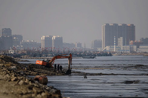
In China alone more than 1.2 million hectares of wetland reclamation has taken place in the last 50 years, perhaps accounting for more than 5 per cent of the worlds’ tidal wetlands.
Credit: Nick Murray

Not only do hundreds of species of migratory bird depend on them for their existence, this coastal ecosystem also protects large chunks of humanity and provides ecosystem services to hundreds of millions of people around the world.

A zone under pressure

The problem for all coastal ecosystems is the shifting character of the coastal zone. The last 50 years has seen the global human population migrating rapidly to coastal regions. As a result, coastlines around the world have become a focus of expansion of urban, agricultural and industrial areas.

This development is having a major impact on coastal ecosystems, which has resulted in the widespread loss and degradation of ecosystems such as mangroves, seagrasses, coral reefs and tidal flats. And that has major consequences for humans and nature.

In terms of the human cost, coastal ecosystems are a frontline defence that protects billions of dollars of infrastructure from storms and sea level rise, and maintaining their integrity is among the most cost-effective options for coastal protection.

Tidal flats are a widespread coastal ecosystem that is frequently overlooked in the planning and management of coastal resources. They are among the most widespread of any coastal ecosystem and, as well as providing ecosystem services to hundreds of millions of people worldwide, they sustain a suite of threatened and declining species.

For instance, tidal flats support the majority of the world’s migratory shorebird species, enabling their yearly migration from the arctic to areas as far south as Patagonia. Unfortunately, their proximity to centres of human population have also made these areas targets for cheap and rapid coastal development.

Drawing a mud map

So, what’s the magnitude of the problem?

Until now we have had no way of knowing just how much of this declining coastal ecosystem has been destroyed, or how much and where it remains. The principal reason for the lack of accurate maps of this ecosystem is due to the rapidly changing conditions they encounter: changing tides either expose or cover them, severely limiting the application of classical remote sensing methods.

To solve this problem, our small team of remote sensors and spatial ecologists have been developing methods to map tidal flats over very large areas.

Using the heavily developed tidal flats of mainland East Asia as a case study, we have developed a rapid mapping approach for identifying the distribution of tidal flats while assessing their changing status at continental scales.

The tidal flats in this region – which fringe the countries of North Korea, South Korea and China – are among the largest in the world, measuring up to 20 kilometres wide in some places. Our methods – utilising free data from the US Geological Survey’s Landsat archives and freely available regional tide models – allow fast implementation across thousands of kilometres.

Indeed, with more than 28,000 images to choose from, we determined the changing status of tidal flats across more than 14,000 kilometres of coastline.

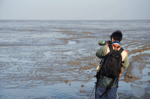
Easily overlooked, and invisible for much of the tide cycle, mud flats are disappearing right before our very eyes. And their loss comes with an enormous cost.
Credit: Nick Murray

Impacts of reclamation

Our results demonstrate that tidal flats in East Asia are being destroyed at rates similar to other major at-risk ecosystems, such as tropical forests and mangroves. The principal cause of these losses related to coastal development. Changes to sedimentation regimes due to the damming of major rivers is also an issue as this results in offshore losses of tidal flats.

In East Asia, land scarcity is a severe issue and often the cheapest method of acquiring land for large coastal developments is through land creation, often termed reclamation. Tidal flats, which are generally characterised by low-sloping flats in areas protected from severe weather, have proven an ideal environment for cheap and rapid coastal development.

This radical transformation involves the construction of seawalls, infilling and finishing for land use. These areas are then developed into new parcels of land for aquaculture, agriculture, suburbs and industry.

Loss of coastal wetlands to land reclamation is a global problem that is severely affecting the world’s coastlines. In China alone more than 1.2 million hectares of wetland reclamation took place in the last 50 years, perhaps accounting for more than 5 per cent of the world’s tidal wetlands according to some estimates.

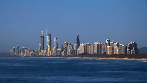
This is clearly a symptom of China’s rapid coastal urbanisation. This arc of growth will form one of the world’s largest urban areas by 2030 – a continuous coastal urban corridor over 1800 kilometres long.

The rapid pace of coastal population growth and sea-level rise – as well as increasing demand for aquaculture, coastal wind farms, and tide energy – will certainly apply further pressure to the world’s tidal flats in the future.

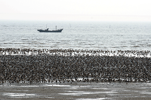
The loss of tidal flats along migratory pathways, especially staging sites (where birds must replenish their energy stores during migration for long, energetically expensive flights) can have extreme consequences for shorebird populations. For the millions of shorebirds that migrate through the East Asian-Australasian Flyway, the intertidal areas of Asia are a crucial migratory bottleneck.
Credit: Nick Murray

Uncertain future

An effective conservation strategy must manage the complex economic and social trade-offs that drive coastal development.

Decision-making that simultaneously plans for coastal development and coastal conservation along the world’s most rapidly developing shores is clearly needed.

For example, places where natural values have effectively been lost due to sediment depletion and coastal subsidence could be prioritised for development. As part of a carefully integrated plan, this could ease pressure on a functioning network of coastal protected areas and ensure continued delivery of ecosystem services.

Not only might this avert catastrophic extinctions of coastal biodiversity, it will also help us ensure we have a coastline capable of adapting to an increasingly uncertain future.

Dr Nick Murray is a Research Associate at the Centre for Ecosystem Science, University of New South Wales. He carried out this research in association with the Environmental Decisions Group (EDG), while completing his PhD at the University of Queensland. The EDG is a network of conservation researchers developing the science of effective decision making to better conserve biodiversity, and includes a number of Australian and International research centres, including CSIRO. This article first appeared in Decision Point – a free monthly online publication from the EDG.

More information

‘Tracking the rapid loss of tidal wetlands in the Yellow Sea’, published in Frontiers in Ecology and the Environment

‘Continental scale mapping of tidal flats across East Asia using the Landsat archive’, published in Remote Sensing

‘IUCN situation analysis on East and Southeast Asian intertidal habitats, with particular reference to the Yellow Sea (including the Bohai Sea)’, IUCN occasional paper


Published: 27 January 2015

Can the property development industry deliver climate-ready cities?

Eddo Coiacetto

Developers often cop criticism for being environmental vandals who’d do anything in the name of profit. But the industry is complex, ranging from one-off ‘mum and dad’ investors to global corporations. One thing they all have in common is that what they produce – residential and commercial developments – will need to perform in future environments that may call into question how or why the structures were built in the first place.

Gold Coast skyline, 2012: Coastal development in south-east Queensland may be impacted by more powerful storm surges and sea-level rise.
Credit: Mike R under CC BY-SA 2.0

There is no ‘typical’ property developer. Private property development is a complex, high-risk industry in which the developer is the entity, person or institution that manages the risks of development.

Unlike builders, developers do not have to be qualified, accredited or registered. While some may come from land-related professions and trades, others may be from unrelated fields, such as mining. Firms can be created specifically for a development project, then dissolve on project completion.

Can an individual developer deliver climate-ready developments? To an extent, some already do. The question though, is whether the entire collective of developers responsible for building cities – the development industry – can do it.

The question is important because developers play a key role in shaping cities.1 Developments contribute to climate change because they impact on energy consumption and greenhouse emissions. New buildings and houses also affect the degree of exposure of users and residents to heatwaves, flooding and other extreme weather events. The extent to which they do depends on factors like:

  1. location

  2. site features

  3. building features, and

  4. private governance arrangements, such as covenants, easements and body corporate rules that developers put it place for users.

Regulation seeks to influence the above characteristics. But land use planning has had little traditionally to say about private governance arrangements. And building standards are relatively unproblematic and acceptable to developers: there is even a significant degree of industry self-regulation via green rating schemes, for example.

Importantly, controlling the location of developments, and to a degree their design, is politically charged, since it profoundly impacts property values and development feasibility.

At this point, it’s worth defining what a ‘climate-ready’ development industry would look like. It would be one that:

  1. has the capacity to, and which can change to, deliver – in both the short and longer-term – products that reduce or minimise users’ exposure to climate hazards, and products that contribute to reducing energy use and GHGs; and

  2. is at the same time resilient to, and has the capacity to deal with, climate change consequences, both direct and indirect.2

Developers’ exposure to the risks of climate change is limited because their commitment to a project is short – from several months to, at most, a couple of decades – compared to the lifetime of that development and the timeframes of predicted climate change hazards, such as sea-level rise.

Further, developers differ in their capacity and willingness to respond to the risks of climate change. They include builders, solicitors, ‘mum and dad’ developers, large diversified global corporations, mining companies, financial institutions and superannuation companies. They may be individuals or corporations, and may also be one-time operators, occasional developers, or professionals. Some developer ‘entities’ merely manage a development project for a fee while passing the risk of development on to equity investors, who may be ordinary people trying to save for their retirement.

Each entity has a different way of operating and some have more power than others to shape their operating environment. That environment is made up of diverse opportunities and risks – such as market risks, site risks, funding risk and planning risk. Different developers respond to the same stimuli (risk or opportunity) in different, even opposite, ways to other developers.

The problem therefore is that there can be no generic industry-wide response to climate change or to a climate -related regulation/policy. In other words, a given policy will not work with all developers.

Take land-use zoning to control the location of development, for example. Some developers only seek out land that is zoned for what they want to use the land for. However, other developers, perhaps with more time or power on their side, search only for land that is not zoned and then seek to rezone it because landowners want too much for zoned land.

As mentioned, the climate risks are not the same for all developers. A developer specialising in marina developments in North Queensland may be exposed to sea-level rise, storm surge and cyclonic activity; whereas one specialising in retirement units in central Queensland may be exposed to bushfires, drought, heat stress and inland flooding.

This discussion has so far focused only on the development industry. But climate-ready development necessitates a whole-of-sector approach, including landowners, financiers, builders and suppliers, engineers, consultants, and designers.

The role of finance is central and critical because it is this capital that is placed at risk in a development.

Policy makers can support the development industry’s adaptation to climate change by providing timely, accessible information.3

Many government departments are the custodians (and originators) of substantial data banks, yet access is often difficult, time-consuming and expensive. Strategies to improve transparency and communication of government data – such as long-term forecasts of storm surge levels – would go a long way to improving development appraisals. The easier the access to information, the more informed the eventual decision: for example, developers might avoid locations and sites at serious risk from climate change impacts.

So, while the outlook for the development industry (and its products) may sound grim, we cannot afford be pessimistic, because climate change presents an unprecedented threat. The solution thus requires an unprecedented level of consistent and concerted action by all players in the property and financial sectors, including all levels of government.

Associate Professor Eddo Coiacetto from Griffith School of the Environment, Griffith University, is interested in improving the effectiveness planning practice by basing it on a sounder understanding of the realities of urban development. Eddo is one of 31 experts who’ve contributed to the edited collection, Responding to Climate Change, published by CSIRO Publishing.


1 Squires G & Heurkens E (2015) International Approaches to Real Estate Development. Abingdon: Routledge.
2 Coiacetto E (forthcoming) Climate change governance in private real estate development: essential concepts about development for feasible research, regulation and governance. In JR Knieling (Ed.) Climate Change Governance: Theory, Concepts and Praxis in Cities and Regions. Wiley.
3 Coiacetto E, Shearer H, Dodson J, Taygfeld P & Banhalmi-Zakar Z (2014 ) One man's meat is another man's poison: why 'who' the developer is matters in climate change adaptation in the development industry. In P Burton (Ed.) Responding to Climate Change: Lessons from an Australian Hotspot. CSIRO Publishing.


ECOS Archive

Welcome to the ECOS Archive site which brings together 40 years of sustainability articles from 1974-2014.

For more recent ECOS articles visit the blog. You can also sign up to the email alert or RSS feed