|
Published:
Linking Sri Lanka’s biodiversity
The tenacious efforts of a small conservation organisation are helping restore indigenous flora and fauna in Sri Lanka’s southern communities through a technique known as Analog Forestry. It may yet link vital remnant forest patches to form an important refuge for the island’s biodiversity. Eric Marx reports.

|
|
Top left: vulnerable frog species Philautus reticulates and top right Philautus popularis; bottom leftthe flower of the majestic cannon ball tree (Couroupita surinamensis); bottom right Sri Lanka’s common green garden lizard that lives in mixed vegetation. Credit: RRI and iStockphoto
|
Sri Lanka was once an island nation so rich in biodiversity that when field researchers from the International Conservation Union (IUCN) re-assessed existing faunal survey data in 2007 for a first ever national endangered species Red List report,1 they were staggered to have to revise three-fold the number of known amphibian species that once inhabited the country.
Rather than rejoice, however, the news came as a shock and raised alarms – nearly all the newly classified creatures were either already extinct or by now critically endangered.
Today, a third of Sri Lanka’s inland vertebrate fauna and more than half of the evaluated flora are threatened. The chief factor, say the report’s authors, has been habitat destruction linked to expanding monoculture crops, resulting in an annual loss of 33 000 hectares of forest cover being recorded since 1995. More than a third of the most precious old-growth forest cover that still stood on Sri Lanka in 1990 had disappeared by 2005.
The message of the IUCN’s authoritative biodiversity assessment was clear: protecting Sri Lanka’s wildlife and their forests will require adopting new models of conservation – quickly.
‘We have seen the habitat area for these threatened species disappear in front of our own eyes,’ says Vimukthi Weeratunga, one of two project managers at The World Conservation Union Sri Lanka who helped prepare the Red List together with the Ministry of Environment and Natural Resources. ‘Thirty-seven species of plants and 21 of amphibians are gone. The numbers are staggering.’
How did this happen?
Competing priorities for government
Approximately 30 per cent of Sri Lanka’s land area falls under some level of natural resource management, but critics say field staff working in the forest and wildlife sectors are severely under-resourced.

|
|
Charith Senanayake (middle back) leads RRI and frequently works with community leaders to advance the merits of Analog Forestry and the rainforest corridor project. Credit: RRI
|
More importantly, the government has yet to take a concerted landscape approach to conservation which goes beyond forest borders to collaborate with local villagers.
Conventional reforestation plans don’t consider connections with the highly fragmented and most biologically important lowland forest in the south-western wet zone. This region is home to 90 per cent of the island’s 830 endemic flowering plants but accounts for less than five per cent of the country’s protected parklands and reserves.
The best known wet zone parkland is the Sinharaja Forest Reserve, the largest rainforest remnant in Sri Lanka and one of roughly 140 forest patches, the smallest of which range from 10 to 25 kilometres in size but nevertheless contain dense pockets of endemic plant and wildlife species.
The stress on these fragments is now excessive, say observers such as Dr Sumith Pilapitiya, the World Bank’s lead environmental specialist for the South Asia region. Pressure from a wave of encroaching small-scale tea farmers continues unabated, while the main priority of the government seems to lie with infrastructure development plans now being given added backing in the present post-war atmosphere.
Eco-tourism that earns extra rupees for buffer communities can counter the demand for land development, but Dr Pilapitiya sees it as only a part-way solution.
‘Nature tourism, while not a panacea, will earn revenue from the forest and prevent its destruction,’ he said in a recent interview. ‘That’s the only hope I see.’
Yet, currently most eco-tourism bypasses the southern wet zone, heading instead to eastern and northern parkland areas renowned for their large game animals and migratory birdlife.
More promising, says Dr Sarath Kotagama, one of Sri Lanka’s leading wildlife ecologists, is the effect of local organisation Rainforest Rescue International’s (RRI) ongoing reforestation project in the wet zone, which aims to use the island’s traditional home garden methods to establish a 15-kilometre long biological corridor connecting the Sinharaja and Kanneliya Forest Reserves.
But while expressing support for the project, Dr Kotagama also voices some skepticism about its immediate chances
of success.
‘At present you have remnant patches very far and wide apart and what you have in between is mostly tea – not home gardens,’ says Dr Kotagama, referring to the wet zone’s one- and two-acre monoculture tea plots. ‘If the extent of the fragmentation is so bad,’ he asked, ‘how successful can they [RRI] be?’
Analog Forestry and Rainforest Rescue International
Trying to compete against an expanding monoculture crop system is going to be difficult, says Charith Senanayake, Rainforest Rescue International’s Managing Director. Still, he envisions that within 25 years the corridor area can be turned into an established green development zone with smallholder farms and commercial plantations deriving income from reforestation on their properties.
|
|
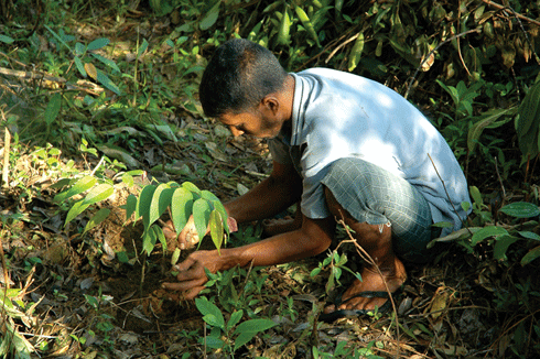
A community member planting a doona seedling, provided by RRI. Doona (Shorea cordifolia) is one of Sri Lanka’s primary endemic rainforest trees. Credit: Charith Senanayake, RRI
|
With the help of revenues from a fledgling eco-tourism program, and support from other non-government organisations, RRI is gradually advancing this ambitious community project. Four years in, Charith’s team has opened educational centres, signed agreements with local politicians, developed relationships with local villagers, distributed thousands of seeds and plants and, most importantly, developed what he believes to be a viable economic alternative to monocropping.
‘The main argument,’ he says, ‘is that it can be economically feasible for smallholder farmers.’
Analog Forestry achieves this, says Charith, by enabling farmers to harvest and derive income from forest-based products – such as herbs and fruits – in addition to their already existing tea crops. Over time, the newly introduced species then mimic native forests by building soil and improving water quality.
A selection of the newly introduced forest species – including everything from creeper vines and epiphytes to shrubs and satinwood trees for canopy cover – is worked out in partnership with the farmer according to his income preferences. These species, in turn, are carefully considered by RRI for their microhabitat potential.
|
|
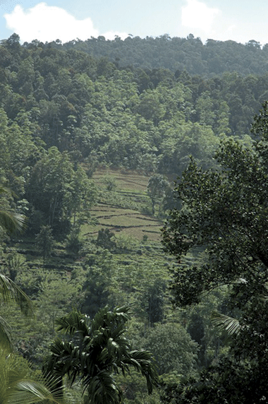
Sri Lanka’s original forest cover has become severely fragmented due to land-use changes, such as for tea plantations. Credit: Charith Senanayake, RRI
|
According to Charith, the analog forest is a perennial polyculture, structurally and functionally analogous to the natural forest. It goes beyond other current agroforestry practices since it focuses on the identification and incorporation of biological diversity within food crop areas.
‘It’s a reference to the forest or ecosystem that existed in an area prior to human change. We try and bring back components of that reference forest ... and we do that in Sri Lanka generally by coming up with a forest garden – because we’re talking about regenerating tropical forested areas with high canopy tree layers.’
Located alongside paddy fields, home gardens have traditionally provided food, fibre, fuel, oil and raw material for medicines. It’s the Kandyan version, however, with its incorporation of exotic crop species introduced by the British, that proved both its capacity for biodiversity promotion and income generation.
Charith’s father, Dr Ranil Senanayake, pioneered Analog Forestry in the early 1980s based largely on experiments at a 14-acre abandoned tea estate where he and roughly 15 colleagues applied ecological sciences to the Sri Lanka forest garden model.
But by 1989 repeated clashes with the authorities found Dr Senanayake out of favour with the government. His residency in Australia at Monash University and subsequent travels working with farmers in field trials established the science of Analog Forestry internationally and popularised its practice in countries ranging from Vietnam and the Philippines to Peru, Canada and Zimbabwe.
But observers say the culmination of his life’s work lies in establishing a biological corridor system for Sri Lanka in the densely populated portion of the southern wet zone lying between the Sinharaja World Heritage Forest Reserve and the lesser known Kanneliya Forest Reserve.
Corridors would allow the movement of biodiversity between the two reserves and outlying forest patches, and should therefore decrease local extinction rates by improving habitat availability. Charith, who has now taken up his father’s cause, says satellite mapping of the roughly 100-kilometre area and field research in the remaining forest patches have confirmed both the existence of high value species and four possible corridors.
It was a project the elder Senanayake set about earnestly pursuing upon his return to Sri Lanka in the late 1990s but which was stymied by funding shortfalls, political resistance and then the 2004 tsunami.
The immediate effect of the tsunami was to throw the corridor plans into disarray. Only one month prior, RRI had made its first purchase of land for the project, a 17-acre plot on which it aimed to develop an education, training and research centre.
Ironically, the tsunami ultimately proved invaluable to the corridor project’s long-term survival. Charith said it was at that point he gave up his Australian tea import business and returned to Sri Lanka to assist in the humanitarian effort and run RRI Sri Lanka.
Working in partnership with other non-government organisations, RRI began employing Analog Forestry to rehabilitate home gardens in the affected south-west coastal zone (see Ecos 141, pp.12–14). It engaged communities and developed valuable relationships with local authorities, while 37-year-old Charith – a far less politically controversial figure than his father – gradually assumed leadership of the corridor effort.
Over the last three years, RRI has moved beyond education awareness and training. Its first reforestation program with 100 smallholder tea farmers in the village of Hiniduma, just outside the Kanneliya Forest Reserve, is underway and Charith says he’s confident farmers will embrace the idea when they start realising economic and biological benefits.
‘They [farmers] are not told to reduce their cropping land by 20 per cent,’ he says, citing a common misconception. ‘What we do is map their land and look for areas that they’re not using – such as riverine and rocky areas – which we then target for planting.’
RRI will, for example, introduce threatened vine varieties such as supsanda (Aristolochia indica), the food plant for the birdwing butterfly (Troides hellena), Sri Lanka’s largest butterfly, but also a nataive medicinal plant which is used in traditional ayurvedic practice.
If you can establish a canopy with different layers and stratas, then Charith says the natural biodiversity returns along with improved soils, water quality and enhanced biodiversity.
Other incentives include a joint program with Conservation Carbon Company providing carbon credit funding to the farmers, and an added option of selling crops under either an organic or Forest Garden Products certification program.
Charith says the lack of funding support for system-based restoration remains an obstacle to broadening the corridor’s impact. He’s greatly encouraged by a pending amphibian restoration study project of the corridor area soon to be issued by the National Geographic Society, but says there’s an urgent need for more targeted research on microhabitats and potential species cross-overs.
‘If we can have four or five individual species crossing from Sinharaja to Kanneliya then we will have a successful program,’ Charith highlights. ‘We still have quite a bit of work ahead.’
More information:
RRI’s Forest Corridor project,
http://www.rainforestrescueinternational.org/case_studies/rcp.html
About Analog Forestry,
http://www.rainforestrescueinternational.org/downloads/analog_forestry.pdf
1 The IUCN Red List of Threatened Species, first prepared in 1948, is the world’s most comprehensive inventory of the global conservation status of plant and animal species. A series of Regional Red Lists are produced by countries or organisations, which assess the risk of extinction to species within a political management unit. The 2007 Red List updated a 1999 list and other national data.