Print this page

Published: 16 April 2012

Green shoots from brownfield roots

Nick Fleming

While brownfield sites present many challenges for developers, they may be the key to sustainable growth in the face of intense population pressures on our cities.

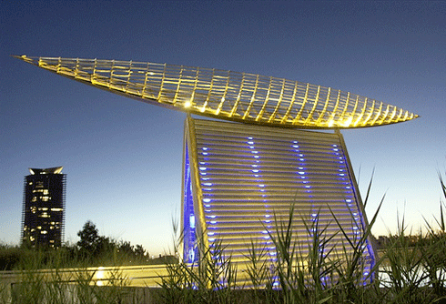
Melbourne's Docklands precinct was developed on a brownfield site. This urban art piece (Reed Vessel by Virginia King), in Docklands Park straddles a pool integrated into the wetlands of the 3-hectare park. Rainwater is collected in a series of three wetlands, then stored underground for use in parkland irrigation. Annual water savings are estimated to be up to 10 million litres.
Credit: Steve Hubbard

Brownfield sites – abandoned or underused industrial and commercial sites – are relics of our past, the legacy of Australia's post-war manufacturing boom and our past history as an exporter.

The decline of manufacturing competitiveness and changes in the use and value of land have left a number of brownfield ‘scars’ across our cities and suburbs. Tackling these challenging sites, and consolidating the opportunities presented, will be key to the prosperity of our cities and their economies.

Australia’s population is projected to reach 35 million by mid-century. Over 70 per cent of the growth is expected to be accommodated by our capital cities.1 Developing brownfield sites to meet the demand for land can present technical and stakeholder complexities that challenge the commercial attractiveness of development.

However, greenfield development also comes at a cost, for different reasons – new infrastructure. Brownfield development, which uses existing infrastructure, can typically save 50 per cent of the development cost of greenfields. This economic efficiency could free up funding for other policy goals, including health and education.

To balance greenfield and brownfield development and limit urban sprawl, many cities are setting targets to guide development. Sydney’s City of cities: A plan for Sydney’s future2 sets a nominal target of 70 per cent infill to 30 per cent greenfield. However, despite a strong strategic and economic rationale, the rates of infill – the term ‘infill’ encompasses sites formerly used for residential purposes – and brownfield development have struggled to keep pace with demand.

Despite the challenges, the development of brownfield sites provides an opportunity to remodel our cities. The provision of green spaces, biodiversity corridors and communal gardens – particularly when done with a master plan that optimises the redevelopment of brown- and consolidated grey-fields3 (middle residential suburbs) – could provide opportunities to reclaim land for other ecosystem services and/or local food production on soils more suitable than for housing.

The scale of some of our capital city inner urban redevelopment sites has led to them being touted as eco-suburbs. These projects include the ‘e-gate’ precinct in Melbourne’s central railyard areas, the City Link area in central Perth, and the high profile Barangaroo redevelopment on the western edge of Sydney’s CBD.

The scale of these precincts also facilitates use of technologies that may not be feasible on a smaller scale. Trigeneration (trigen) is a form of localised energy production: gas-fired units generate electricity and deliver it locally, avoiding some of the high costs of transmission. The heat from electricity production is captured and used to heat and cool buildings and waste heat is converted to chilled water for air-conditioning and refrigeration. Trigen systems are more than twice as energy-efficient than a coal-fired power station and emit less than half the greenhouse gas emissions.

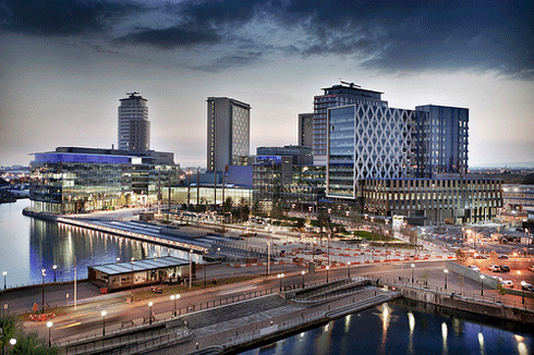
MediaCity in Manchester in the United Kingdom is a hub for creative and digital services.

Precinct-wide trigen is part of the MediaCityUK development, a new hub for creative and digital services in Manchester in the United Kingdom. At Wembley City, a residential, leisure and shopping complex being built around the new Wembley sports stadium north-west of central London, underground waste vacuum systems that use suction pipes to transfer waste to a central treatment plant have been installed. Water-sensitive design is a feature of Melbourne’s Docklands development.

Development at this scale also enables a mix of land-use types to be incorporated into a precinct, including shared public space, which contributes to community vibrancy.

Capitalising on these opportunities will require tackling the key challenges. Innovative approaches such as the brownfield sustainability pilots, brokered by the USA’s Environmental Protection Authority, provide grants and technical and regulatory support to help overcome barriers such as the cost and risk of managing contamination.

Navigating the complex web of stakeholder interest is at the heart of the challenge. Local communities have strong opinions about the fate of brownfield sites, as do regulators, local councils and developers, and all have differing interests. Commercial and industrial land-use priorities compete with residential demands, and locations that provide access to a skilled workforce and necessary infrastructure are in high demand.

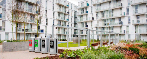
Vacuum waste inlets, Wembley City, UK. Vacuum waste systems use suction pipes to transfer waste to a central treatment plant. The scale of Wembley City facilitates use of technologies such as this that may not be feasible on a smaller scale.
Credit: Envac Group

Given these challenges, we may need different commercial models to incentivise appropriate development that recognises whole-of-life costs and benefits. We may also need different ways of achieving collaboration along the supply chain, to avoid setbacks arising from the separation of functions among multiple agencies and authorities, which characterises urban development projects.

Our cities are already feeling the strain of population growth. It is clear that a ‘business as usual’ approach will not meet the challenge of accommodating the future needs of our growing cities. Developing transition pathways is important to make sustainable growth achievable, step by step.

Science will help us understand how best to create and implement those transition pathways, recognising they are complex and involve many stakeholders. We also need good real-world examples that are attractive to people and demonstrate what is possible. Brownfields may be relics of our past, but a prosperous future will require grasping the opportunities they present.

Dr Nick Fleming is Chief Sustainability Officer at Sinclair Knight Merz, leading the application of sustainability thinking in business operations and client services. Through his Sustainable Enterprise column, Nick provides insight into how businesses and organisations are effectively putting sustainability theory into practice.


1 Infrastructure Australia (2010). State of Australian cities 2010. Major Cities Unit, Infrastructure Australia, Canberra. http://www.infrastructure.gov.au/infrastructure/mcu/soac.aspx
2 NSW Department of Planning (2005). City of cities – a plan for Sydney’s future: the metropolitan strategy. NSW Department of Planning.
3 Peter Newton (2010). Beyond greenfields and brownfields: the challenge of regenerating Australia’s greyfield suburbs. Built Environment 36(1), 81–104.


Published: 2 April 2012

Computer power stacks up for flood mitigation

Carrie Bengston

The best tools to mitigate the effects of floods such as those we’ve seen recently literally splashed across our TV screens may not be levies or sandbags, but computers.

CSIRO’s computational fluid modelling expertise has enabled Chinese authorities to visualise what would happen if one of their largest dams – Geheyan – were to fail, sending 3.12 billion cubic meters of water crashing onto the town below. The colours denote different floodwater velocities.
Credit: CSIRO

Wee Waa, Moree and Wagga Wagga – towns that to many people have previously been just dots on maps – recently made headlines, for all the wrong reasons. TV news footage showed these towns deluged with murky water from rivers swollen by record downpours. Residents, emergency services and local mayors could only assess the damage and do the best they could as they waited for damaging flood waters to recede.

While floods like this will always occur, it is possible for agencies and communities to prepare and respond more effectively. Computer power is the key: it can model fluids such as flood waters incredibly accurately. Data about specific landscapes and regions can be combined with mathematical equations of how fluids behave and move, helping emergency managers, town planners and even insurance companies be prepared for future floods.

The data deluge in sciences such as environmental modelling is every bit as awesome as the real-life deluges experienced recently in NSW. Resource managers and planners are beginning to take notice of the power of computational fluid modelling for understanding and analysing vast amounts of environmental data, and for predicting changes due to floods. Computer modelling power is based on both the power of computers themselves and the power of the algorithms (computer processing steps) that run on computers.

Twice each year, the world’s fastest supercomputers are ranked in the ‘Top500 list’. A standard test called the Linpack benchmark compares computers' speeds and energy consumption. Computer owners such as universities and government data centres, technology companies such as Intel, and supercomputer geeks all eagerly await the latest list.

In November 2011, for the first time, the number one computer on the list – Japan’s ‘K computer’ – clocked in at more than 10 petaflops, doing more than 10 quadrillion calculations per second.1

Less than three years ago, these speeds were unimaginable. Every ten years, supercomputers speed up about 1000 times. (This acceleration in processing power eventually makes its way to our desktops, mobile phones and other devices.)

The head of CSIRO’s computational and simulation sciences team, Dr John Taylor, leads teams of researchers with expertise in statistics, mathematics, information and communication technologies and other areas of science. The teams analyse large datasets from huge sensor networks such as radio telescopes, large experiments such as those using the synchrotron, and high-throughput DNA analysis systems.
Credit: CSIRO

CSIRO’s greenest supercomputer – a relatively new type of supercomputer called a graphics processing unit (GPU) cluster – has made the Top500 several times since its launch in November 2009. It ranked 212 in the November 2011 list.

Located in Canberra, it’s one of the world’s fastest and least energy-hungry supercomputers. Intriguingly, the GPUs at its heart started out as graphics rendering hardware for computer games. So, it’s no surprise that the cluster – now a workhorse for many scientists in CSIRO – can produce informative and stunning animations as it rapidly crunches enormous numbers of numbers.

‘In recent years, the huge increase in computer power and speed, along with advances in algorithm development, have allowed mathematical modellers like us to make big strides in our research,’ says Mahesh Prakash of CSIRO's computational modelling team, led by Dr Paul Cleary.

‘Now, we can model millions, even billions of fluid particles,’ says Dr Prakash. ‘That means we can predict quite accurately the effects of natural and man-made fluid flows like tsunamis, dam breaks, floods, mudslides, coastal inundation and storm surges.’

Dr Mahesh Prakash is one of a team of computational modellers at CSIRO who’ve clocked up several decades of work on fluid computer models and algorithms, including rendering to create ‘real life’ 3D wave and flood effects.
Credit: CSIRO

A dam break, for example, is essentially a human-made flood. Like a flood caused by excessive rainfall, a dam break can be modelled on computer.

The models create colourful and detailed animations that show how rapidly the water moves and where it goes: where it ‘overtops’ hills and how quickly it reaches towns or infrastructure such as power stations. This information can help town planners plan structures such as levies and help emergency services respond more efficiently.

CSIRO’s dam break models have been validated using historical data from the St Francis Dam break, which occurred in California in 1928 and killed more than 400 people. Dr Prakash and his team have used the validated modelling techniques for a range of ‘what-if’ scenarios for other dams.

Working with the Chinese Academy of Surveying and Mapping, the CSIRO team simulated the hypothetical collapse of the massive Geheyan Dam: one of the world's biggest. CSIRO combined their unique modelling techniques with digital terrain models (3-D maps of the landscape) to obtain a realistic picture of how a real-life disaster might unfold.

Realistic animations help flood mitigation and emergency response groups to better manage disasters.
Credit: CSIRO

These evidence-based fluid-modelling tools can also help decision makers manage dam operations during excessive rainfall, for example, allowing them to determine when to undertake controlled water releases and how much water to release.

The future of computer modelling of floods and other natural disasters can only improve as computers and algorithms become more powerful. CSIRO's own supercomputer arsenal will be given a boost when its GPU cluster is upgraded this year. The tender was won by Xenon Systems of Melbourne and the upgrade is currently taking place.

The leader of CSIRO’s computational and simulation sciences team, Dr John Taylor, says the upgrade will open up even more possibilities.

‘We're anticipating a significant boost in computational performance and greater compatibility with the next generation of accelerator cards, all achieved using less energy per calculation,’ says Dr Taylor.

Flood modellers, regional planners and emergency managers – watch this space!

View a clip on computational fluid modelling for disaster management here.


1 In supercomputing, flops – or more accurately, flop/s, for floating-point operations per second – is a measure of a computer's performance, especially in fields of scientific calculations that rely on floating-point calculations. The prefix ‘peta’ denotes 1015 or 1 000 000 000 000 000 flops.


ECOS Archive

Welcome to the ECOS Archive site which brings together 40 years of sustainability articles from 1974-2014.

For more recent ECOS articles visit the blog. You can also sign up to the email alert or RSS feed