Print this page

Published: 23 April 2012

Sustainable neighbourhoods: the cohousing model

Gilo Holtzman

The ‘housing crisis’ in our cities is firmly on the national agenda. Gilo Holtzman reports on a long-standing housing model that offers the promise of affordability, sustainability and social cohesion.

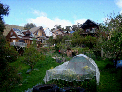
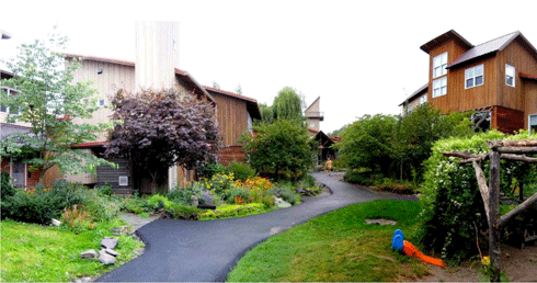
Cascade Cohousing, Hobart, was built in 1995. About a quarter of the land is preserved as open space and most of this is regenerating to the natural bush of the region. Between the regrowth and the housing are orchards, gardens and a chook run.
Credit: Gilo Holtzman

Social isolation, rising housing costs, congestion, increasing petrol, energy and water bills, and living long distances from family, friends and jobs: these issues are only a fraction of our modern living inheritance in Australian cities. Together with climate change challenges and shrinking green space, these problems have led to the pursuit of alternative, more sustainable and more affordable ways of housing and living.

According to a recent Grattan Institute survey, Getting The Housing We Want, ‘Contrary to myth and assumption, Australians want a mixture of housing choices – not just detached houses. Many want to live in a semi-detached home or an apartment in locations that are close to family or friends, or to shops.’ Australians also want neighbourhoods that are more lively, friendly and safe.

In creating our future neighbourhoods, whether they are newly built or retrofitted, in urban infill, the fringe, or brownfields developments, our biggest challenge is to find the formula that will create resilience in our living arrangements. Our models need to meet the challenges of our time while also ensuring longevity.

For the last 40 years, one innovative housing model has demonstrated, through design and resource sharing, the capacity to develop a neighbourhood characterised by strong social cohesion and a reduced environmental footprint. This is cohousing.

Cohousing is a type of intentional community where a group of people, independently or in partnership with developers, organise to create a collaborative neighbourhood, an alternative way of living based on mutual respect for each other and the environment.

Cohousing neighbourhoods vary in size, ranging from 12–36 households, with an ‘ideal’ population including at least 50 adults of a range of ages, plus children. The focus is on the people: cars are parked at the periphery of the site and the physical design encourages both social contact and private space. Private homes contain all the features of conventional homes, but residents also have access to communal facilities such as an open space, courtyards, a playground and a common house where optional shared meals are prepared and eaten with neighbours and other social events occur.

EcoVillage at Ithaca, New York State, USA. Ecovillage at Ithaca comprises three ‘neighbourhoods’. This one, known as ‘FroG’ (from “First Residents Group”), was completed in August 1997. It was the first completed cohousing project in New York State.
Credit: Gilo Holtzman

The cohousing model involves participation by residents within a non-hierarchical management structure, fostering shared decision-making that is focused on creating and maintaining a caring community, encouraging the development of meaningful relationships between neighbours, and ensuring that residents feel a sense of belonging. This is in line with the idea of ‘neighbourhood development corporations’, proposed in Getting The Housing We Want, as a way to empower residents to be more active in their neighbourhood planning decisions, ensuring that they have a real say in the future of their neighbourhoods.

This involvement in management tends to encourage a sense of physical safety, where neighbourly networks keep an eye out for residents. For households that include children, the communities offer youth role models and supervision from a broader range of adults than simply parents. The physical layouts of the neighbourhood buildings encourage this and also can create financial opportunities for residents.

Much of the social recycling, sharing and food-growing initiatives evolving in our cities – community gardens, sustainable streets, home harvest swaps, free-cycling, sharehoods – occur naturally in the cohousing neighbourhood setting. A quarter of Australian households already consist of people living on their own – including single parent families and older people. Now more than ever, the type of community building encouraged by cohousing is needed.

Of this growing sole-person household population, Peter Mares of The Grattan Institute says: ‘This demographic reality means that there are a growing number of Australians who are at greater risk of social isolation and loneliness, which, as our report Social Cities shows, are correlated with poor health outcomes. In this context, we find it surprising that there is not more innovation in housing arrangements, including more investigation of the potential for cohousing as one alternative approach.’

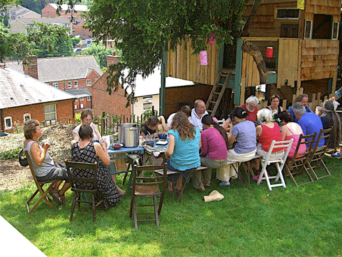
Sharing a meal at Springhill Cohousing, Gloucestershire, UK. Springhill comprises 35 homes, ranging from five-bedroom houses to one-bedroom flats. It was completed in 2006 and was the first new-build cohousing scheme to be finished in the UK.

Cohousing was pioneered in Denmark in the 1960s by a group of working parents who realised that if they shared many of the household tasks across the community, they would have far more time to socialise, to be with their children and it would also reduce their cost of living. 1

The cohousing movement is gaining momentum around the world. In Sweden and Holland it is well established as a social housing (public housing) and senior housing alternative. In the US and other countries in the world, cohousing neighbourhoods are making inroads into the mainstream housing market.

However, in Australia the cohousing model has been slow to develop. Contributing factors include the culture of housing in this country with its post-war tradition of high rates of home ownership on the quarter-acre block, high land prices, lack of government incentives and complications at the local government level.

The first Australian cohousing neighbourhood, ‘Cascade Cohousing’ in Hobart, was established in 1991. Sixteen small-footprint households housing 20 adults and 16 children live there. The houses are oriented to the north and have high thermal mass. After 21 years, it is still going strong and demonstrating its relevancy to our present and future needs. Today there are three more existing cohousing neighbourhoods: ‘Pinakarri Community’ in Fremantle WA, ‘Cohousing Cooperative’ in Hobart and the newly occupied ‘Ecohousing Heidelberg’ cooperative in Melbourne. A few more initiatives are in various stage of development.

One design aspect that is common to many cohousing neighbourhoods is the tendency to build in clusters. This allows for a smaller footprint per dwelling, leaving more open space for the community to share. Building in clusters also saves on building materials and reduces heating and cooling energy costs. The grouping of dwellings together, extensive common facilities and shared amenities encourage pro-environmental behaviour among residents.

Cohousing makes significant space, energy and materials savings possible. A 2005 study of cohousing in the US found on average 31% space savings, 57% electricity savings, and a saving of 8% on materials. 2

One of the key virtues of the cohousing model is the flexibility it gains from being based on the needs and capabilities of those it is intended to house. It can be adapted for social housing and senior housing as well as cooperative, residential land trust or ecovillage settings. Although cohousing is likely to remain a relatively small proportion of housing in any country, it has great potential to influence housing, neighbourhood and urban design generally. 3

Sustainable practices in cohousing

  1. smaller dwelling sizes and allotments allow for more shared open space

  2. focus on energy efficiency

  3. use of solar energy

  4. shared resources such as meeting facilities

  5. residents engaging in bartering services (such as trading items, and fruits and vegetables)

Gilo Holtzman is a building designer working in the field of cohousing. He is a member of Cohousing Australia, is a co-founder of the E-Co-Neighbourhood Blue Mountains and is a partner in Synthesis Studio, an architecture practice specialising in environmentally and socially sustainable design.


1 Holtzman G (2010). Introduction to Cohousing and the Australian Context .
2 Williams J (2008). Predicting an American future for cohousing. Future 40, 268–286.
3 Bamford G and Lennon L (2008). DES 18 Cohousing and rethinking the neighbourhood: the Australian context. BEDP Environment Design Guide 54(5), 1–10.


Published: 2 April 2012

Computer power stacks up for flood mitigation

Carrie Bengston

The best tools to mitigate the effects of floods such as those we’ve seen recently literally splashed across our TV screens may not be levies or sandbags, but computers.

CSIRO’s computational fluid modelling expertise has enabled Chinese authorities to visualise what would happen if one of their largest dams – Geheyan – were to fail, sending 3.12 billion cubic meters of water crashing onto the town below. The colours denote different floodwater velocities.
Credit: CSIRO

Wee Waa, Moree and Wagga Wagga – towns that to many people have previously been just dots on maps – recently made headlines, for all the wrong reasons. TV news footage showed these towns deluged with murky water from rivers swollen by record downpours. Residents, emergency services and local mayors could only assess the damage and do the best they could as they waited for damaging flood waters to recede.

While floods like this will always occur, it is possible for agencies and communities to prepare and respond more effectively. Computer power is the key: it can model fluids such as flood waters incredibly accurately. Data about specific landscapes and regions can be combined with mathematical equations of how fluids behave and move, helping emergency managers, town planners and even insurance companies be prepared for future floods.

The data deluge in sciences such as environmental modelling is every bit as awesome as the real-life deluges experienced recently in NSW. Resource managers and planners are beginning to take notice of the power of computational fluid modelling for understanding and analysing vast amounts of environmental data, and for predicting changes due to floods. Computer modelling power is based on both the power of computers themselves and the power of the algorithms (computer processing steps) that run on computers.

Twice each year, the world’s fastest supercomputers are ranked in the ‘Top500 list’. A standard test called the Linpack benchmark compares computers' speeds and energy consumption. Computer owners such as universities and government data centres, technology companies such as Intel, and supercomputer geeks all eagerly await the latest list.

In November 2011, for the first time, the number one computer on the list – Japan’s ‘K computer’ – clocked in at more than 10 petaflops, doing more than 10 quadrillion calculations per second.1

Less than three years ago, these speeds were unimaginable. Every ten years, supercomputers speed up about 1000 times. (This acceleration in processing power eventually makes its way to our desktops, mobile phones and other devices.)

The head of CSIRO’s computational and simulation sciences team, Dr John Taylor, leads teams of researchers with expertise in statistics, mathematics, information and communication technologies and other areas of science. The teams analyse large datasets from huge sensor networks such as radio telescopes, large experiments such as those using the synchrotron, and high-throughput DNA analysis systems.
Credit: CSIRO

CSIRO’s greenest supercomputer – a relatively new type of supercomputer called a graphics processing unit (GPU) cluster – has made the Top500 several times since its launch in November 2009. It ranked 212 in the November 2011 list.

Located in Canberra, it’s one of the world’s fastest and least energy-hungry supercomputers. Intriguingly, the GPUs at its heart started out as graphics rendering hardware for computer games. So, it’s no surprise that the cluster – now a workhorse for many scientists in CSIRO – can produce informative and stunning animations as it rapidly crunches enormous numbers of numbers.

‘In recent years, the huge increase in computer power and speed, along with advances in algorithm development, have allowed mathematical modellers like us to make big strides in our research,’ says Mahesh Prakash of CSIRO's computational modelling team, led by Dr Paul Cleary.

‘Now, we can model millions, even billions of fluid particles,’ says Dr Prakash. ‘That means we can predict quite accurately the effects of natural and man-made fluid flows like tsunamis, dam breaks, floods, mudslides, coastal inundation and storm surges.’

Dr Mahesh Prakash is one of a team of computational modellers at CSIRO who’ve clocked up several decades of work on fluid computer models and algorithms, including rendering to create ‘real life’ 3D wave and flood effects.
Credit: CSIRO

A dam break, for example, is essentially a human-made flood. Like a flood caused by excessive rainfall, a dam break can be modelled on computer.

The models create colourful and detailed animations that show how rapidly the water moves and where it goes: where it ‘overtops’ hills and how quickly it reaches towns or infrastructure such as power stations. This information can help town planners plan structures such as levies and help emergency services respond more efficiently.

CSIRO’s dam break models have been validated using historical data from the St Francis Dam break, which occurred in California in 1928 and killed more than 400 people. Dr Prakash and his team have used the validated modelling techniques for a range of ‘what-if’ scenarios for other dams.

Working with the Chinese Academy of Surveying and Mapping, the CSIRO team simulated the hypothetical collapse of the massive Geheyan Dam: one of the world's biggest. CSIRO combined their unique modelling techniques with digital terrain models (3-D maps of the landscape) to obtain a realistic picture of how a real-life disaster might unfold.

Realistic animations help flood mitigation and emergency response groups to better manage disasters.
Credit: CSIRO

These evidence-based fluid-modelling tools can also help decision makers manage dam operations during excessive rainfall, for example, allowing them to determine when to undertake controlled water releases and how much water to release.

The future of computer modelling of floods and other natural disasters can only improve as computers and algorithms become more powerful. CSIRO's own supercomputer arsenal will be given a boost when its GPU cluster is upgraded this year. The tender was won by Xenon Systems of Melbourne and the upgrade is currently taking place.

The leader of CSIRO’s computational and simulation sciences team, Dr John Taylor, says the upgrade will open up even more possibilities.

‘We're anticipating a significant boost in computational performance and greater compatibility with the next generation of accelerator cards, all achieved using less energy per calculation,’ says Dr Taylor.

Flood modellers, regional planners and emergency managers – watch this space!

View a clip on computational fluid modelling for disaster management here.


1 In supercomputing, flops – or more accurately, flop/s, for floating-point operations per second – is a measure of a computer's performance, especially in fields of scientific calculations that rely on floating-point calculations. The prefix ‘peta’ denotes 1015 or 1 000 000 000 000 000 flops.


ECOS Archive

Welcome to the ECOS Archive site which brings together 40 years of sustainability articles from 1974-2014.

For more recent ECOS articles visit the blog. You can also sign up to the email alert or RSS feed