|
Published: 9 July 2012
Dr Dirk Mallants: expert on groundwater and patience
Groundwater specialist Dr Dirk Mallants of CSIRO understands the importance of patience. As he explains to ECOS in this interview, the timescales on which groundwater processes operate can be as long as millennia.
|
|
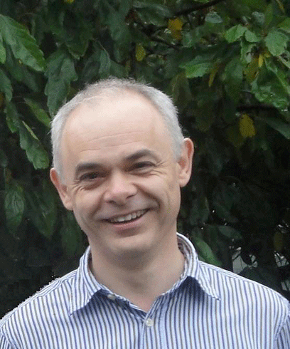
Dr Mallants, CSIRO Groundwater Hydrology Program Leader Credit: CSIRO
|
Dr Mallants is based in Adelaide, Australia's city of churches, and hails from the University of Leuven, Belgium, another city of churches.
An expert in soil and groundwater hydrology, Dr Mallants leads a team of CSIRO researchers working on understanding groundwater in Australia. Some of the issues the team addresses are:
-
current and future availability of groundwater
-
how groundwater reserves are naturally replenished
-
how groundwater contributes to maintaining streamflow
-
how climate change affects groundwater availability
-
the degree to which ecosystems, plants and animals depend on groundwater for their survival.
Can you give an example of how findings from CSIRO groundwater hydrology projects have been applied in the real world?
In the irrigation-intensive areas of the Murray–Darling Basin, much of the land is salt affected. CSIRO has contributed to establishing a long-term management strategy for community-based groundwater and salinity in these areas.
Disposal basins are used to store subsurface drainage from irrigated land, so that farmers can remove salt from the plant root zone and decrease salt export from irrigated areas into rivers. In the Riverine Plain region of Victoria and New South Wales, the number of small, on-farm (1–5 ha) and large, community (20–100 ha) disposal basins has increased in recent years, due to regulations limiting the export of salt from irrigation areas. The design and management of on-farm and community basins vary widely, because they were developed under different administrative frameworks.
The CSIRO groundwater hydrology project team investigated and modelled the hydraulic, chemical, and groundwater processes occurring in disposal basins and surrounding land in the Riverine Plain region. From this, we developed tools to improve basin siting, design, management, and cost-effectiveness, as well as principles and guidelines for optimum design and management of small-scale basins.
What are some of the challenges Australia faces in better understanding and managing its groundwater resources?
One of the key science challenges relates to how groundwater is recharged, or replenished: a complex process that involves timescales ranging from years to millennia. Sustainable use of Australia’s groundwater resources is based on knowing the amount of recharge, as this determines the maximum level of renewable resource.
Over long timescales, diffuse recharge is the amount of precipitation that is not lost to the atmosphere by soil evaporation and plant transpiration, and to the rivers by surface runoff. However, recharge is difficult to measure or estimate, particularly considering the enormous spatial dimension of the Australian landscape.
Typically, recharge is calculated from the difference between precipitation on the one hand, and evaporation and transpiration on the other. But, small errors in these water balance components may lead to large errors in the recharge component: especially if the recharge is just a few millimetres per year.
Another approach to measuring recharge is to take specific measurements at different sites (point-scale estimates): for instance, based on an analysis of the chloride balance of soil profiles. But, these point-scale measurements are difficult to extrapolate or upscale to large areas, because of variability in soils, sediments, and vegetation.
The challenge is to develop a link between small-scale and large-scale representations of the recharge process in a physically consistent way. For example, on the small scale, recharge estimates may be made by determining the age of groundwater using isotopic techniques. On the larger scale, we have flow models for groundwater and for the movement of water through the ‘unsaturated’ zone1 of the ground. So, the question becomes: can we integrate some of these techniques to give us more certainty when we model groundwater, so that we can have greater confidence in our recharge estimates, and therefore in our determinations of the maximum level of renewable resources?
|
|
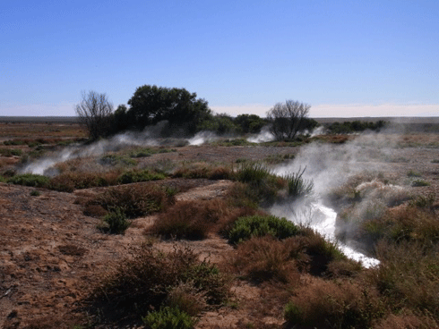
Steam emanates from a drain connected to the Mirra-Mitta bore, Great Artesian Basin, South Australia. Hot water flows constantly from this 1000-m deep bore, which was sunk in the year 1901. Credit: CSIRO. Photo by Jan Mahoney
|
Prior to joining CSIRO, you worked in Europe and elsewhere on waste and contamination management issues in the nuclear industry. How does your expertise in soil physics relate to how nuclear waste is managed or contamination avoided?
The basic principle of safe management of radioactive waste is based on the ‘concentrate and confine’ concept. The waste product is concentrated and immobilised in a relatively small volume and then disposed in natural materials, such as deep clay layers, or artificial materials, such as concrete, that are more impermeable to water. As a result, transport of the radionuclides2 through such materials is virtually zero. Principles of soil physics demonstrate that the contaminants remain safely within the repository until most of the radioactivity has decayed.
Principles of soil physics – such as transport of heat, water and matter through a porous soil – are applicable in any porous medium, whether soil, clay, granite or even concrete. Compared with soils, deep clay layers are easier to deal with, because they are relatively homogeneous, remain water-saturated, and their physical characteristics do not change over reasonable timescales.
Many of the research tools – such as numerical models and tracer data - I and my colleagues in the nuclear safety field used are identical to the ones being used in coal seam gas (CSG) studies. Coal seam gas studies must consider the same properties of aquitards (relatively impermeable rock or clay layers that limit groundwater movement into, or out of confined aquifers), to determine how CSG extraction from isolated aquifers impacts on aquifers that are a major source of water for other uses.
You have been involved in stakeholder engagement and collaboration – aimed at promoting greater understanding, and potentially, acceptance of potentially controversial government policy and decisions. Can you give an example of one of these issues that you worked on and perhaps the approach taken?
I have indeed been very fortunate to have interacted widely with different non-technical stakeholders throughout my career as a scientist. The science behind the development of nuclear waste repositories is still very contentious in western democracies, and so I have worked hard on advancing understanding of the science through community partnerships. In this approach, engagement, interaction and cooperation with local communities is central to the process of facilitating acceptance of potentially controversial government decisions.
Members of local partnerships – such as regulatory agencies and the public at large – become involved in the project at a very early stage. Also, real decision power is granted to the partnerships and a very intense dialogue is maintained between all parties. I believe that much of the success of the partnerships in which I was involved was due the extensive effort made to communicate complex science in accessible terms – through, for example, public lectures and workshops.
|
|
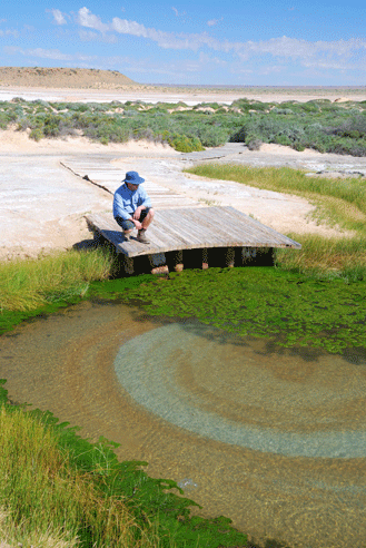
A mound spring known as ‘the bubbler’ on the western edge of the Great Artesian Basin, South Australia. This spring has been flowing for thousands of years. Credit: CSIRO. Photo by Glenn Harrington
|
Do you think the community partnership approach could be or has been useful for groundwater policy in Australia?
Elements of this approach have universal applicability in other domains, including the development of sustainable water resources management. It has become clear in recent years that any large or potentially controversial technical, infrastructure, or even groundwater management project requires broad political and social acceptance to be successful. This, in turn, requires both technical and social confidence that the project is necessary, environmentally sound and will be well implemented.
This holds true in the case of Australia’s groundwater, as well as water policy more generally. For stakeholders to have confidence in the results and conclusions drawn from hydrogeological assessments, they need information provided in a transparent and traceable manner. They also need to be confident that the science used – for example, the conceptual models and computer codes – are fit for purpose and have been used appropriately.
Confidence in hydrogeological assessments is also boosted by uncertainty management: the science of considering relevant uncertainties, and either addressing them or acknowledging their effects. Uncertainty analysis is also a key element of developing a long-term R&D program. It helps prioritise data collection – for example, directing research towards those subsurface hydrological processes and parameters that contribute most to model prediction uncertainty.
Who has inspired and motivated you in your career ?
Dr. Martinus (Rien) van Genuchten, who is by far the most-cited soil hydrologist, with more than 15 000 lifetime citations. He conducted most of his work at the United States Salinity Laboratory in Riverside, California.
However, it is not necessarily Rien’s citations that have inspired me, as much as his unsurpassable energy, his genuine desire to help and connect people, and his ability to make complex science comprehendible and accessible. Rien has given his profession enormous visibility and scientific credibility, while at the same time making his theories and models readily available to potential users. Despite his successes, he has remained a very humble and amiable person, always ready to share.
|
|
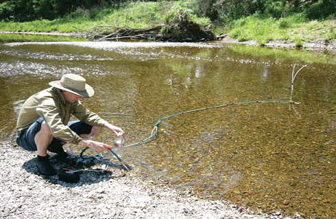
Radon sampling at Cockburn River, NSW. Credit: CSIRO
|
Do you have a favourite quote?
‘There is no greater impediment to progress in the sciences than the desire to see it take place too quickly’ – G.C. Lichtenberg, 1742–1799.
Can you tell us how this need for a long-term approach plays out in the field of groundwater hydrology?
Groundwater hydrology, especially in Australia, is complicated by the extraordinarily large dimensions of some of the aquifers (e.g. the Great Artesian Basin is one of the largest known groundwater reservoirs in the world, covering approximately 1.7 million square kilometres) and by their interfaces with surface environments, rivers and oceans.
For example, the aquifers of Australia’s sedimentary basins can cover thousands of square kilometres, and contain several permeable layers separated by poorly permeable layers (aquitards). Furthermore, the complex movement and interactions of different layers of water in aquifers are often difficult to detect.
Groundwater generally travels slowly in the subsurface, with groundwater age varying from several years to centuries or even millennia. Moreover, low flow rates through aquifers can cause considerable time lags before the consequences of groundwater abstraction by pumping are detected. Effects of climate change (e.g. reduced precipitation) can lead to less groundwater recharge, but in slowly reacting groundwater systems, this may not be quickly detected. Therefore, we need long-term monitoring of groundwater levels and pressures to detect such deferred consequences.
Long records of groundwater levels (and where relevant, surface-level records) – usually over several decades – are also needed, to calibrate and validate the groundwater models that we use to underpin sustainable groundwater management. Monitored aquifers can be considered as long-term natural laboratories used to characterize groundwater resources in specific climatic and land-use settings.
The art of science is being patient and cautiously observing changes in the data being collected. A long-term strategy provides a solid basis for capitalising on field-based research, and the return on previous research investments is amplified as more data are collected. Each new observational study within a natural laboratory adds to the database, improving the conditions and opportunities for future work.
More information
Groundwater Hydrology Program, CSIRO
Groundwater, National Water Commission
1 The zone in which the pore spaces and fractures in soil and rock contain both air and water. It contrasts with the saturated zone, in which all the pore spaces and fractures between soil and rock particles are saturated with water.
2 Nuclear radiation is radioactivity that comes from the nucleus of certain chemicals. These chemicals are called radionuclides and are unstable. Radionuclides give off energy and particles as they decay (break down).