

|
Published: 1 October 2012
Fancy visiting a coral reef? Dive into Google Maps
Australian researchers are involved with a new initiative that will allow people around the world to be virtual onlookers in marine science expeditions through using Street View in Google Maps.
|
|
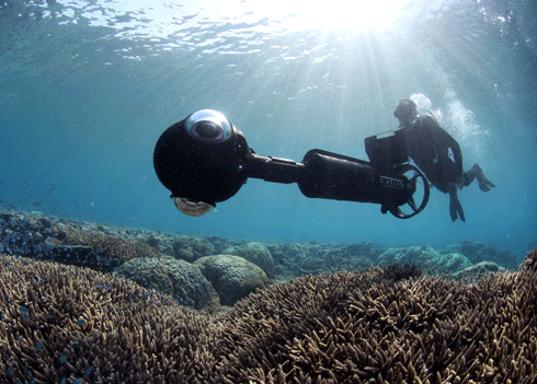
Road-testing some of the new camera equipment in the Great Barrier Reef. Credit:
Catlin Seaview Survey
|
The first application will allow users to take a virtual dive on the Great Barrier Reef in the first leg of an international scientific expedition known as the Catlin Seaview Survey. The survey is a series of expeditions over the coming months to explore and survey the world's coral reefs. Expedition progress is being made available through Google Maps.
Using specially designed technology and the world’s first tablet-operated underwater camera, the survey team will bring the experience to life by taking up to 50,000 images that will be collected through continuous high-resolution, 360-degree panoramic imagery.
When stitched together, these images will allow people to choose a location along the Great Barrier Reef, and go for a viewer-controlled virtual dive in Google Maps.
The project’s chief scientist, Professor Ove Hoegh-Guldberg from the Global Change Institute at The University of Queensland, said all the scientific data gathered would be made public in a Global Reef Record database.
‘The Global Reef Record is a game-changing scientific tool that scientists around the world will have at their fingertips. They will be able to monitor change in marine environments now and in the future.
‘Marine scientists researching any aspect of the reef will be able to study these environments from any of the surveys we conduct – Shallow Reef or Deep Reef,’ Professor Hoegh-Guldberg said.
‘It’s incredibly rewarding and exciting to be leading a talented team of scientists as the first Catlin Seaview Survey expedition begins. The possibilities of what we will discover about coral reefs are almost endless.
‘And right now, information on how these endangered ecosystems are responding to climate change is incredibly important, given that almost 25 percent of marine species live in and around coral reefs.’
The special collection of underwater imagery highlights areas in the Great Barrier Reef and several other underwater spots in the Philippines and Hawaii.
The first Catlin Seaview Survey expedition on the Great Barrier Reef and Coral Sea set off on 16 September. The survey runs until the end of December and will visit 20 separate coral reefs along the 2,300 km reef on an unprecedented scale and depth range – including sections of the reef that have never previously been seen or studied before.
It will then continue on to selected global locations in 2013 including Hawaii, the Philippines and Bermuda.
Source: Catlin Seaview Survey

