

|
Published: 26 August 2013
Global sea-level rise temporarily halted by Australian floods
New research shows that when three atmospheric patterns came together over the Indian and Pacific oceans in 2010 and 2011, they drove so much precipitation over Australia that the world's ocean levels dropped measurably.
|
|
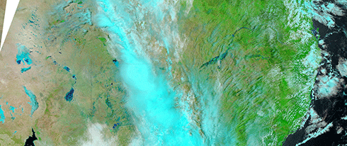
Because of Australia’s low-lying interior, most of the heavy rainfall of 2010 remained inland rather than flowing into the oceans. Credit:
NASA
|
The research, led by scientist John Fasullo from the National Center for Atmospheric Research (NCAR) in the US, was published in Geophysical Research Letters.
Unlike other continents, Australia’s soils and topography prevent almost all of its precipitation from running off into the ocean.
The 2010–11 event temporarily halted a long-term trend of rising sea levels caused by higher temperatures and melting ice sheets. However, now that the atmospheric patterns have snapped back and more rain is falling over tropical oceans, the seas are rising again, faster than before.
In recent decades, as the climate has warmed, the world's oceans have been rising by around 3 millimetres annually. This is partly due to expansion as the water heats up, and partly due to runoff from retreating glaciers and ice sheets.
But for an 18-month period beginning in 2010, the oceans mysteriously dropped by about 7 millimetres, more than offsetting the annual rise.
Last year, Fasullo and his co-authors published research demonstrating that the reason had to do with the increased rainfall over tropical continents. They also showed that the drop coincided with the atmospheric oscillation known as La Niña, which cooled tropical surface waters in the eastern Pacific and suppressed rainfall there while enhancing it over portions of the tropical Pacific, Africa, South America, and Australia.
But an analysis of the historical record showed that past La Niña events only rarely accompanied such a pronounced drop in sea level.
Using a combination of satellite instruments and other tools, the new study finds that the picture in 2010 was uniquely complex. A rare combination of two other semi-cyclic climate modes came together to drive such large amounts of rain over Australia that the continent, on average, received almost 300 millimetres of rain more than its average.
Because of the low-lying nature of Australia’s eastern interior and the lack of river runoff in its western dry environment, most of the heavy rainfall of 2010 remained inland rather than flowing into the oceans. While some of it evaporated in the desert sun, much of it sank into the dry, granular soil of the western plateau or filled the Lake Eyre Basin in the east.
‘No other continent has this combination of atmospheric set-up and topography,’ Fasullo says. ‘Only in Australia could the atmosphere carry such heavy tropical rains to such a large area, only to have those rains fail to make their way to the ocean.’
Since 2011, when the atmospheric patterns shifted out of their unusual combination, sea levels have been rising at a faster pace of about 10 millimetres per year.
Scientists are uncertain how often the three atmospheric events come together to cause such heavy rains over Australia. Fasullo believes there may have been a similar event in 1973–74, which was another time of record flooding in that continent. But modern observing instruments did not exist then, making it impossible to determine what took place in the atmosphere and whether it affected sea level rise.
Source: EurekAlert!/NCAR

