

|
Published: 7 November 2013
Unchartered waters: project to turn ocean images into national data bank
A computer-aided project to process and store visual underwater data from around Australia will, for the first time, enable continental-scale analysis of marine ecosystems, according to Australian researchers.
|
|
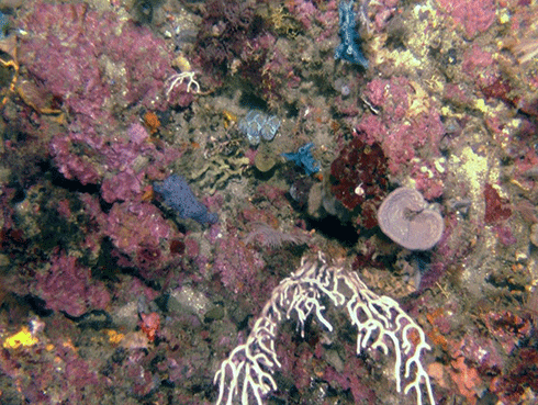
Marine Hub researchers monitoring marine environments in the Solitary Islands Marine Reserve (where this photo was taken) and the Flinders Commonwealth Marine Reserve are using the standardised classification scheme developed through CATAMI. Credit:
Nicole Hill, University of Tasmania
|
Applications include monitoring to support marine bioregional plans and management of the Commonwealth marine reserve network.
The collaborative national project, CATAMI (Collaborative and Automated Tools for Analysis of Marine Imagery and Video), combines a new classification system that ensures marine life forms seen on underwater images are given consistent names, with a web application to enable researchers to input, process, store and compare visual data.
CATAMI was developed by researchers involved with the NERP (National Environmental Research Program) Marine Biodiversity Hub.
According to Dr Nicole Hill, an Institute for Marine and Antarctic Studies post-doctoral researcher with the hub, analysing visual data is a non-destructive way of assessing both the physical and biological marine environment. It has particular relevance for improving understanding about the marine communities protected by marine reserves and monitoring how these marine communities change through time.
‘Once we have the imagery, we need to extract meaningful evidence for managers that provides insights about progress toward management objectives, such as improved ecological understanding or mitigation of undesirable impacts,’ she said.
CATAMI delivers a standardised framework to maximise the value of the data by making sure everyone is speaking a common ‘language’.
By having the data in a common format, in the one place, researchers can compare and/or aggregate data sets collected by different institutions to answer broad-scale questions relevant to agencies such as the Commonwealth Department of the Environment.
Franzis Althaus, who has been analysing visual data at CSIRO for 13 years and is applying this knowledge to Marine Hub research, says species-level identification isn’t always possible from visual data.
'We needed a hierarchical classification system that labels marine life in consistent ways. For example, at the most general level, a seaweed might be classed as “macroalgae”, then, more specifically, as “erect coarse-branching”, and, finally, as “brown”, “red” or “green” algae,’ said Mrs Althaus.
Broad-scale questions that CATAMI will help answer could include: What is the distribution and relative abundance of corals across tropical Australia? What does the change in abundance of an indicator species (or broad organism type, eg tall sponges) tell us about fishing pressure off Australia’s coasts? How are Australia’s marine communities changing with the climate?
Other efficiencies expected to flow from having CATAMI act as a central repository for marine data: scientists from different institutions will be able to access it online at the same time, encouraging a collaborative environment and producing data that can be aggregated.
Source: NERP

