

|
Published: 13 October 2014
Research expedition could improve tsunami risk estimates for the Pacific
A western Pacific Ocean submarine plateau, likely formed in the largest volcanic eruption in Earth’s history 122 million years ago, will be profiled in an intensive study being led by Tasmanian marine geoscientists.
|
|
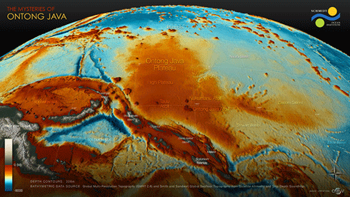
The Ontong Java Plataeu Credit:
Schmidt Ocean Institute
|
The 35-kilometre thick Ontong Java Plateau north of the Solomon Islands is a submerged seafloor platform almost the size of Western Australia. The shallowest point of the high plateau is approximately 1500 metres beneath the surface, and several atolls and islands surmount the submerged plateau.
Chief Scientist on the voyage, Professor Mike Coffin from the University of Tasmania (UTAS) – has been studying the region since 1995, participating in four geophysical expeditions and one scientific ocean-drilling expedition.
Prof Coffin will lead the $1.3m October voyage on the Schmidt Ocean Institute vessel, RV Falkor in a search for evidence that may help explain what happened following the plateau’s main constructional phase. They will use advanced swath-mapping technologies to characterise the topography of the plateau.
‘As marine geophysicists with a long interest in the formation and evolution of the Ontong Java Plateau, we will be collaborating to produce seafloor maps that will improve tsunami predictions for people living on its surmounting younger atolls as well as provide the first information on development of a major submarine canyon incising the plateau.’
Involving Australian, German, Japanese, Papua New Guinea, UK, and US researchers, the study will shed light on evolution of two Pacific atolls, now inhabited by about 2500 people.
This will be achieved through mapping of the seafloor and the shallow sub-seafloor around the two atolls and a submarine canyon that appears to emanate from the atolls.
The project is supported by the Australian Research Council, the UK’s Natural Environment Research Council, and IMAS, while the Schmidt Ocean Institute is providing ship time.
Prof Coffin said mapping and other research at the plateau has been severely limited, both because of the scarcity of ships with advanced sonar systems such as Falkor’s, and because the area is so remote. The plateau’s geological origin and development remain enigmatic mainly because of that limited work.
‘The catch is that the top of the 122-million-year-old volcanic rock now lies beneath several kilometres of seawater and a kilometre-thick blanket of sediment, thus making it difficult for researchers to access it.
‘Long-running international scientific ocean drilling programs have worked on the plateau, but getting that far down through that much sediment is an expensive and time-consuming process.’
Prof Coffin said fossils found in sediment samples immediately overlying the 122 million year old volcanic rock are from the same geological epoch – Early Cretaceous. That’s why scientists are reasonably confident that the plateau was formed in a single, massive release of magma. The total release is estimated to have been more than a million times larger than the largest volcanic eruption in recorded history.
New technologies and autonomous vehicles are enabling scientists to explore deeper and further. But deep ocean exploration, including the Ontong Java Plateau study, received a setback in May this year when the hybrid remotely operated vehicle ‘Nereus’ imploded at about 10,000 m water depth during a study of the Kermadec Trench in the Pacific Ocean.
Daily updates on the three-week RV Falkor voyage can be found here.
Source: UTAS

